

“Massive destruction on a proportion never seen”
Island and shore path take a beating.

BAR HARBOR—Bar Harbor’s famous Shore Path is closed.
After significant damage to the path in yesterday’s mammoth storm, the path has been cordoned off to protect the public and prevent further erosion. Wednesday’s storm brought gusts of over 75 mph in the Down East region, moved a camp out to sea, and caused damage to multiple roads and structures throughout Mount Desert Island. It also left more than 14,000 Versant customers without electricity.
Its impact in Bar Harbor was heavily felt with some still assessing damages today.

“This is massive destruction on a proportion never seen before on the Shore Path in my lifetime,” said Bar Harbor Village Improvement Association President Dickie Cough. “It will take more money than we have to repair it all, so we will need to start raising money immediately.”

Massive portions of the path no longer exist. Nearby, the Bar Harbor Inn’s pier has a gawping hole in it. Damage to the Harborside Hotel and cruise ship tendering area and shops was also readily apparent as business owners assess damages.
video courtesy West Street Cafe
But the Shore Path is a different beast. It’s part of Bar Harbor’s lure and its history. Less than a mile long one way, it’s a staple for visitors and a major place of vacation photos and memories.
The Bar Harbor Village Improvement Association keeps the publicly accessible path clean and groomed so that people can visit Frenchman’s Bay without leaving the land. The Shore Path begins at the Bar Harbor Inn or the town’s Ells Pier and ends at Wayman Lane. Different property holders own different portions of the path.
According to the association’s website,
”This lovely walking path was made possible by the VIA working with the landowners who generously sacrificed their privacy so the public could enjoy this amazing walk. In return, the VIA accepts the responsibility and costs for maintaining the path and seawall improvements. Please do respect their property and privacy while enjoying this gem. ”The Shore Path dates to 1880. The VIA has made significant improvements to the gravel surface and stone retaining walls. We also added stone benches in 2012 and historic informational panels in 2013. The section of path between Agamont Park and Grant Park was recently widened from three feet to six feet to better accommodate current foot traffic.”
Throughout the year, tourists and locals stroll and saunter around a little point of land and past the inn along a gravel path that hugs the coast line. Toward town in the spring, there will be wild roses, fences on private property in various states of repair.
“This is the fourth damaging storm this winter and we've already talked with Harold MacQuinn Inc. about assessing the damage and prioritizing repairs,” Cough said. “Weather will play a role as to when major repairs can get started, as it will be necessary to replace entire sections of seawall. It’s also apparent the existing height of the seawall is no longer sufficient to keep the storms off the path so that must be addressed, too.”
“The path is closed until further notice ,” Cough said.
The organization’s board issued the following statement:
“The Bar Harbor Shore Path is on land that is privately owned by the abutting landowners. They have for years generously allowed the use of their land. The Shore Path is maintained by the Bar Harbor Village Improvement Association. “In light of today’s storm and the significant damage which has occurred to the shore path from the Bar Harbor Inn to Wayman Lane, and with consideration to public safety, the BHVIA has closed all access points, from the Town Pier, from Grant Park and from Hancock Street and Wayman Lane. “We would ask the public that for everyone’s safety, this closure be respected until further notice.”

During the January 10, Comprehensive Planning Committee meeting, Town Council Chair Valerie Peacock mentioned the town’s need to deal with such events as the storm that can damage roads and other infrastructure.
“I think we need to start thinking differently,” Peacock said about “planning for a different future of resilience” in places like Ells Pier, which was pummeled by storm surge and damaged.

Maine DOT’s Director of Communications Paul Merrill said the DOT has been focused on resilience efforts in recent years because of the changing climate.
“Those efforts involve planning for higher sea-level rise and upsizing culverts,” he said. Some of those efforts are detailed on the DOT’s site.
The costs of cleaning up properties on public and private lands is still being determined.
BAR HARBOR ROUTE 3/HULLS COVE/OCEANARIUM/ACADIA
The Bar Harbor Oceanarium and Education Center near the head of the island had significant flooding, too. Private videos show deep water forming waves throughout the property. The Oceanarium is expected to release photos and a statement later today.
“It’s flooded,” said a staff member on the uploaded video.
Plow trucks removed debris that washed up in Hull’s Cove, blocking the roadway, Wednesday morning.

In Acadia National Park, Sand Beach was covered with water and waves crashed up the access stairs. Nearby, Thunder Hole was filled with water, large rocks were tossed onto the Park Loop Road and there was some erosion. The Schoodic portion of the park was also heavily impacted by storm surge combined with wind and tide.
Isle au Haut, part of Acadia National Park, experienced a 95-mph gust.

The Tay , a schooner that wrecked in July 1911 and had been buried under sand dunes, came into the air on Wednesday after massive amounts of sand was washed away. Crew clung to the schooner’s mast during the storm that contributed to its sinking. One by one, they swam ashore, all surviving except for the cook, J. B. Whelpley.
As Acadia National Park’s website reads,
“The Tay quickly broke to pieces. Clinging on for dear life to the broken mast, the Tay’s crew waited till the tide went out so they could scramble to the safety of the sandy beach. The crew found refuge in the Satterlee Family’s summer home. A large portion of the Tay’s cargo, close to ninety thousand feet of spruce planks, was washed ashore by the waves. The lumber was salvaged by many local islanders as well as the Satterlee family, who built a boathouse with salvaged lumber to honor the shipwreck.”
Louise Satterlee was J.P. Morgan’s daughter.
The storm that did in the Tay also wrecked a catboat, pushing it up on Rodick Island. Another accounting of the wreck specified that its cargo was spruce shingles. According to the Bar Harbor Record, it was a southwest wind that broke the ninety-four feet long schooner that had been built in 1887.
SEAL HARBOR BEACH/LITTLE LONG POND AREA/ROUTE 3 AND OTHER ROADS
Route 3 by Little Long Pond in Mount Desert is closed. The sea wall was pounded down and swept both in and out during the storm.
Seawall in Southwest Harbor has closed. Peabody Drive in Northeast Harbor was closed. Route 3 in the Thompson Island area was down to one lane.
The Bernard wharf and dock had storm surge damage and is closed The Tremont Road in Tremont experienced serious flooding.

Seal Harbor Beach also did not fare well. The Rockefeller Boat House on Dodge Point Road had emergency response staging as a propane leak on the road necessitated attention. The road itself was shut down in sections.

According to the Schoodic Institute, “higher sea levels mean that storm waves and flooding are also higher. The worst case scenario of a storm arriving at the same time as a king tide occurred December 2022. A three-foot surge in water levels provided a glimpse of average sea level rises in the future.”

The water hit those marks on Wednesday.
SATURDAY’S STORM
Meteorologists predict another storm Saturday that also has high winds.

WHAT TO DO IF YOU HAVE DAMAGE
From the maine coast fisherman’s association:.
Earlier today, we shared that individuals and businesses whose working waterfront or fishing businesses were impacted by the recent storm should share those impacts and losses with their local municipality. The response was so overwhelming that the Maine Emergency Management Agency has stepped in to help streamline the reporting process by providing an online survey to fill out instead of calling your local town hall . "It is imperative that individuals of private industry and privately owned commercial infrastructure who sustained property damage from the January 10th storm, including wharfs, floats, vessels, etc. document and report that damage." Commissioner Keliher (Department of Marine Resources) HOW TO REPORT DAMAGE The online Initial Damage Assessment Survey can be found HERE . This is not an application for assistance nor a guarantee of financial assistance. Submission of damage information will help the State of Maine understand the extent of damage from the January 10th storm. Individuals who sustained damages to their primary residence are encouraged to document and report that damage by filling out the Individuals & Households Initial Damage Assessment Survey ( HERE ). MCFA will be updating our website and Facebook with information and links.
Contact Monique Coombs if you need assistance with the survey. [email protected]
FROM THE MAINE DEPARTMENT OF MARINE RESOURCES
Yesterday's storm has resulted in unprecedented damage to property along Maine's working waterfront. DMR is working closely with Governor Mills and the Maine Emergency Management Agency as we assess the extent of the damage to Maine's coastline. DMR, with the support of the Maine Forest Service, will be conducting an aerial survey along the coast today, documenting the damage. It is imperative that individuals with damaged property from yesterday's storm, including wharfs, floats, vessels, etc. document that damage, share that information with their local municipality, and ask their municipality to report documented damage to the appropriate Maine county emergency management agency . Please share this information with anyone on Maine's working waterfront who may have experienced damage from this storm. In the meantime, please be aware of areas along the coast, both on land and on the water, where there may be hazards as a result of yesterday's storm and proceed with caution. Also, please note that we have a similar storm coming this weekend with an even higher tide, so it’s clear that additional preparations will be needed. DMR will continue to evaluate this situation and will communicate updates from the Governor's office and from MEMA as efforts to recover from this storm move forward.
NEEDS YOUR HELP

If you have still images of the storm, please think of sending them to the MDI Historical Society. It needs your help. The Society is looking for images from the storm for a project they are doing with the Schoodic Institute on sea level change. They are particularly looking for images from today from the head of the island, Bass Harbor marsh, and Seal Cove/Pretty Marsh areas. Please send to [email protected] with info about when the image was taken/where the image was taken/who took the image.
LINKS FOR MORE INFORMATION
To donate to the Village Improvement Association
To donate to the Oceanarium
To donate to the MDI Historical Society
Storm Smashes Into MDI

BAR HARBOR—High winds and high tide have combined to cause damage throughout Mount Desert Island today, January 10. High tide was shortly before 9:30 a.m. The Bar Harbor Inn’s pier has taken on significant destruction and General Manager Jeremy Dougherty suggests people avoid the Shore Path from Grant Park to the town pier. The below images and video is …
Bar Harbor’s Shore Path

Goldie. Hunter. Rosie. Otis. Necromancer. Alice. Spartacus. Woof Doggy. There is a seemingly never-ending stream of canines that gallivant down Bar Harbor’s Shore Path on Frenchman’s Bay. Their leashes are long, short, red, chained, leather, canvas and sometimes non-existent as they sniff their way down the well-groomed gravel path past rocks and ocean,…
This story was updated to include a statement from the Maine Coast Fisherman’s Association. 12:30 p.m. January 11. It was updated to include a statement from the Maine Department of Marine Resources at 2: 18 p.m.
Bar Harbor Story is a mostly self-supported publication and covering this storm did us in a bit this week, putting us behind on our paying work, so we might be a bit slower for a couple of days. To receive new posts and support our work, consider becoming a free or paid subscriber. Thanks for being here with us and caring about Bar Harbor, too.
Ready for more?
Weather | 18-foot waves pummel piers, chunk out sand and…
Share this:.
- Click to share on Facebook (Opens in new window)
- Click to share on Twitter (Opens in new window)
- Click to print (Opens in new window)
- Click to email a link to a friend (Opens in new window)
- Click to share on Reddit (Opens in new window)
Today's e-Edition
- Latest News
- Environment
- Transportation
Weather | 18-foot waves pummel piers, chunk out sand and flood parking lots along Southern California coast

Big waves – some topping 18 feet in Los Angeles County – wreaked havoc on Friday, Jan. 6, as high tides and a winter swell continued to work over the Southern California coastline leading to beach erosion, pier closures, crumbled asphalt parking lots and boats torn from their docks.
In the South Bay, piers at three west-facing beaches remained closed Friday as waves more than 15 feet tall pummeled the structures.

In Seal Beach, high surf and wind pummeled the pier, and officials decided to “temporarily close it in an abundance of caution.” Part of the boat ramp used by oil platform workers was damaged. (Photo by Mark Rightmire, Orange County Register/SCNG)

High surf along west facing beaches in the southland had the Manhattan Beach Pier closed on Thursday January 5, 2022. (Photo by contributing photographer Chuck Bennett)

Waves crash over the Redondo Beach break wall near the King Harbor Yacht Club on Thursday, Jan. 5, 2023. A series of storm systems moved into the area, causing waves upwards of 12 feet high along the South Bay coast. (Photo by Maxwell at eMaximize.com)

A man treks out to the shore despite rain in Long Beach on Thursday, January 5, 2023. (Photo by Brittany Murray, Press-Telegram/SCNG)

Large waves hit the pilings of the Huntington Beach Pier early Friday morning, January 6, 2023 in Huntington Beach. The recent storm that brought rain, wind and snow to most of California, has also brought large, and in some areas, damaging surf. (Photo by Mark Rightmire, Orange County Register/SCNG)

Water from a large shorebreak wave makes its way nearly a hundred yards up on to the beach just south of the Huntington Beach Pier early Friday morning, January 6, 2023 in Huntington Beach. The recent storm that brought rain, wind and snow to most of California, has also brought large, and in some areas, damaging surf. (Photo by Mark Rightmire, Orange County Register/SCNG)

A beach goer looks on as a large shorebreak wave hits the beach just south of the Huntington Beach Pier early Friday morning, January 6, 2023 in Huntington Beach. The recent storm that brought rain, wind and snow to most of California, has also brought large, and in some areas, damaging surf. (Photo by Mark Rightmire, Orange County Register/SCNG)

Additionally, the high surf and tide surge swamped a block jetty at Cabrillo Beach in San Pedro, flooding and closing the nearby parking lot. Mounds of sand buried a bike path that runs from Torrance Beach to Avenue H in Redondo Beach and sea water flooded into a parking lot and public bathroom facility.
In King Harbor, massive waves overwhelmed a breakwater jetty and ate into the asphalt parking lot nearby.
“There were 15-foot-plus waves breaking directly onto the rocks at Redondo Harbor,” said Lifeguard Capt. A.J. Lester, a spokesman for Los Angeles County’s Fire and Lifeguard Division. “The parking lot is built on the rocks of the breakwater and the pressure caused the asphalt to break apart like it was an earthquake.”
The piers at Hermosa Beach, Manhattan Beach and Venice Beach were closed in an “abundance of caution” because of the strong west-northwest swell, which crashed surf over the top of the structures. It arrived Thursday along with the rainstorm and was expected to last through Friday, coinciding with a period of high tides.
The piers will remain closed until city crews assess the structures to ensure they haven’t been compromised, likely a day or two, said Capt. Kealiinohopono Barnes, also with the Los Angeles County division.
“It’s a question of stability after such a prolonged force from the waves,” he said. “The beaches there will remain open, but there is a water quality advisory all through Santa Monica Bay.”
In Seal Beach, high surf and wind pummeled the pier, and officials decided to “temporarily close it in an abundance of caution” and to allow for inspection, the city announced Friday. Part of the boat ramp used by oil platform workers was damaged. No timeline for reopening was given.
Crews from the Orange County Fire Authority and Seal Beach Public Work’s Department built sand berms to reinforce the beach. OCFA heavy equipment crews were also busy Friday digging and draining water from the north side of the pier to prevent seawater from entering any structures and homes.
Surf off Manhattan Beach at El Porto hit as high as 18 feet, though other areas of county shore were more manageable.
“We’ve had considerable erosion,” Barnes said of the waves that ate at the sand. “We’ve lost so much in a short timeframe.”
In Laguna Beach, high waves tore down parts of a sea wall at a home in North Laguna, flooded the coastal side of Coast Highway and Broadway, damaged the foundation of a lifeguard tower at Oak Street leaving it tilting toward the surf zone and tore off railing and staircase steps at Woods and Moss beaches.
Aliso Beach’s parking lot was temporarily shut Friday after flooding, but its east side was opened later in the day. The west side of the lot remained closed while crews continue to clear debris. Officials expected work to continue Saturday.
In Capistrano Beach, the parking lot was also closed most of Friday, but reopened by the end of the day.
Lifeguards caution that though the waves might look tempting for surfers, those who go out

should be sure of their abilities. Especially in the next few days, as the surf declines, the water may appear more welcoming, but the threat of rip currents will be greater – especially along the South Bay beaches where the sea floor has gotten carved up more from all the turbulence and wave action.
“That’s when we see a lot of rescues, because the rip currents get really strong and people get caught in them,” Barnes said.
Water quality is also a concern after rain storms, which can wash inland runoff with pollutants and debris to the ocean. Officials typically advise staying out of the water for 72 hours after a storm. On Friday, Orange County health officials were recommending staying out of the water until at least Monday.
- Report an error
- Policies and Standards
More in Weather

Environment | Scientists hack weather satellite data to quantify methane leaks

Weather | A California superbloom is springing to life and the best is yet to come

Weather | Flowing falls, rivers, full reservoirs: Rain brings a water wonderland to Southern California

Things To Do | Why Mt. Baldy can be deceptive, deadly for novice and skilled hikers alike
Big waves pummel coastline, force Seal Beach pier closure in aftermath of storm

LOS ANGELES (KABC) -- Massive waves continued to pound the beaches and piers of Southern California on Friday a day after a powerful storm exited the region.
The big surf forced the closure of the Seal Beach Pier, where large chunks of wood could be seen floating underneath the structure.
Damage to the pier included a boat ramp used by oil-platform workers. City officials will need to assess the structure before they can determine when the pier could be reopened.
In the meantime, big crowds gathered along the shoreline to watch the spectacle, not just in Seal Beach but in ocean communities throughout Southern California.
"This is the biggest South Bay (waves) we've seen probably ever since I was 10 years old," said Hunter Jones of Manhattan Beach.
The high surf advisories for Los Angeles and Orange counties are expected to remain in effect until 6 p.m. Friday.
Forecasters were expecting waves of 8-10 feet, with some even hitting 12 feet.
In the aftermath of a major winter storm, waves on Friday morning were soaring over a 20-foot break wall at Redondo Beach.
"Today was actually one of the first times in 20 years that we were confronted with this amount of storm surge that's breaking significantly over the break wall -- 40 feet, if I had to guess," said one beach visitor.
At Redondo Beach's King Harbor Yacht club, the waves were big enough to flood the parking lot while also slamming into a retainer wall. A marina employee said the damage will be expensive to repair.
Many people turned out to witness the giant waves as they pummeled beaches in the South Bay.
"I just love seeing the spray, the water," said a woman who visited El Porto Beach. "It's almost like seeing clouds floating in the water. It's crazy."
The conditions at that beach were described as unfavorable for even experienced surfers.
Latest forecast for Southern California

In Ventura County, docked boats were seen being rocked and swayed by the storm waves.
Friday's relatively calm weather conditions were a lull that was expected to be brief as more Pacific storms lined up to blast into California, where successive powerful weather systems have knocked out power to thousands, battered the coastline, flooded streets, toppled trees and caused at least six deaths.
"A very active weather pattern across the Pacific Ocean will continue to push energetic and fast-moving low pressure systems toward the West Coast," the National Weather Service said. "California continues to take the brunt of the heavy precipitation and strong winds associated with these systems as we head into the first full weekend of 2023."
The Associated Press contributed to this report.
¿Quieres leer este artículo en español? Haz clic aquí
Related Topics
- VENTURA COUNTY
- LOS ANGELES COUNTY
- ORANGE COUNTY
- REDONDO BEACH
Top Stories

West Hills woman gets 20 years for fraud scheme involving forged wills

Prosecution wants Rebecca Grossman's phone privileges revoked in jail

Everything to know about D23: Ultimate Disney Fan Event
- 3 hours ago

Dr. Dre receives star on Hollywood Walk of Fame

Boyle Heights artist painting Shohei Ohtani mural in Little Tokyo
- 8 minutes ago
Amazon truck carrying hundreds of packages overturns in San Bernardino
3 charged for stealing $310K in items from luxury retailers in CA
US Supreme Court allows Texas to enforce SB 4 immigration law
clock This article was published more than 45 years ago
Opinion Maine's Keepers of the Very Rich
The caretakers of seal harbor, me.
SEAL HARBOR, Maine -- "I'm going to miss the place," says Clyde Carter in a mellifluous Maine drawl that drops the Rs and makes Jimmy Carter's speech sound like High Diction. "You get attached to a house after a while."
At the peak of his career as the town's premier caretaker, Carter, 42, suddenly finds himself out in the cold a man without a big house. His boss, Nelson Rockfeller, is selling the summer "cottage," a 21-room, horseshoe-shaped castle of granite and glass perched high on 3 acre of brooding Maine coast. The price tag on the parcel is $1 million.
The vagaries of summer gentry affect small towns all along the coast of Maine. After all, the state is a relic of 17th century England, inhabited by woodsmen, watermen and guides serving the pleasure-seeking summer people, as Arnold Toynbee suggested, and Seal Harbor is Maine's most exclusive town of caretakers.
For two months a year, July and August, the bluest of blood pretend to be just plain folks, fleeing the cities for the opportunity to cruise the roads in their "woodies," hear seals yapping for supper and wait in line for a haircut. Docks discreetly court the "discriminating yachtsman" in the Red Book, the quasi-official list of summer residents.
J. P. Morgan used to sail into the exclusive coves of Mount Desert Island on his yacht, the Corsair, and employ was obtained after the fashion of competitive bidding. As a boy, Police Chief Maitland Murphy, now 53, remembers standing on the shore, cheering his father as the proud caretakers raced against each other in rowboats. Several scions took pleasure in awarding their summer accounts to the first man to reach the yacht.
More often, though, the jobs were tenured, passing down from one generation of caretaker to the next, inherited in the manner of property.
CLYDE CARTER was born here. For the last 14 years, he has cleaned Nelson Rockfeller's heated salt-water pool, kept the pipes from freezing in winter, raised enough flowers to fill a castle and fended off the interlopers. He has rousted campers from their sleeping beds in the middle of the night, and shooed gawkers from the grounds.
At night, he usually goes home to sleep, but has come to consider "The Anchorage" just as much as his house as Nelson Rockefeller's.
After the sale, he'll continue tending the boathouse, a converted coal shed where Rockefeller plans to keep an office, Picassos in the sail lockers, an international racing yacht and three other boats.
But it has been decreed: The cottage must go.
Clyde Carter left the island once, to sample New Jersey on a construction job. He scampered home. His father, a carpenter and 30-year Rockefeller veteran, had informed him that Seal Harbor's First Family was hiring.
"I was on my way back anyway," he says. "I didn't like it down there at all." He gazes out across the dark blue water as he talks, waving at lazy seagulls floating by and plump mallards paddling about. His son, Carl, is playing on the dock, an 11-year-old who is carefree and innocent to the ways of big cities.
"How could a person stay away from all this?" asks Carter.
ROCKEFELLER'S father, John D. Jr., or "Junior" as the benefactor is gratefully remembered hereabouts, also fell in love with the Maine coast, specifically the rugged landscape of Mount Desert Island, and brought his wife, Abby, to summer here. In 1908, Nelson was born in the summer cottage they had rented at Seal Harbor, a remote inlet facing the Atlantic.
Two years later, Junior purchased a 99-room mansion, the Eyrie, set high above the harbor, installed an Armenian to care for his priceless oriental rugs and hired more than enough help to landscape the grounds and spill out 15 servants' bedrooms.
John D. took daily hikes about the manor. Once, the story goes, he stopped to chat with the blacksmith, who didn't recognize his lord. It appeared as if Junior wanted a job. "Forget about that," snarled the smithy, "the old SOB ain't hiring."
A crew of piano movers is said to have once tipped a ragged-looking old man 50 cents for lending a shoulder. John D. reportedly pocketed the tip and toddled off.
He never gave out free advice, but his entrepreneurial spirit evidently rubbed off on the help. A group of caretakers crowded themselves "The Big Five" and did rather well doing general contracting for the rich. Two sons of caretakers, Bob Suminsby and Dwight Carter, are now among the area's leading realtors.
"A young fella growing up in this environment ends up with a great deal more sophistication than a typical "Down East Mainer,'" explains Suminsby.
The town was also a summer testing ground for Junior's five boys, who set up a flower stall outside the country club and cornered the market on corsages. One day as they were hitchhiking back to the Eyrie, a summer resident stopped to give them a lift, goes the tale.The driver sniffed surprise that a young Rockefeller didn't have a car. "Who do you think we are, Vanderbilts?" came the reply.
A wall was constructed around the Eyrie, and dappled with sparkling tile taken off the Great Wall of China. Junior proceeded apace to buy up vast tracts of land surrounding his Shangri-La, and, as would become a Rockefeller pattern of environmental noblesse oblige, he presented it to the federal government.
The 5,000-acre Acadia National Park nearby, a playground for 2 million visitors each year, is a spellbinding carpet of lush pine and birch forest that rolls gently across granite mountains and frames crystalline lakes.
Such a grand gesture, of course, was tax-deductible, and created a comfortable green buffer between the rich and the rest. If Junior couldn't make nature a monopoly, at least he would forever insure his market share of it. A taxpayer-subsidized DMZ would stiff-arm the common camper and keep tacko subdivisions from ever tiptoeing upon his heady spaces.
To fend off curiosity-seekers and nurse their properties back from the naughty ravages of winter, the Rockefellers and their landed neighbors hired caretakers, proud ancestors of men like Clyde Carter. These locals - "Maine-iacs," they call themselves - are straight-talking and stubborn, a determined breed rooted umbilically to place and family. Poverty and John D. Rockefeller not withstanding, it is a fair bet they would have remained here anyhow, even if it meant limping along. Which it often did.
SEVEN HUNDRED DOLLARS was all the money Cecil Carter (no relation to Clyde) earned one year in the '30s. "That was tough," he says. "But we got by - smelting fish, gardening, digging clams."
Then he found work as a night watchman at the Eyrie. He says John D. gave strict orders not to feed the night watchmen, never said hello when he came or goodbye when he left. "Meanest man that ever lived," says Cecil. Such are the ways the rich are remembered.
"There was always a feeling you had to look up to 'em because that was your living," he says. "You always tipped your hat and never looked 'em in the eye when you talked."
He is 78 now, a thin, feisty old man soon to retire from his second caretaking job for a wealthy Philadelphia matron. She's selling her modern house on a cliff for $600,000, so Cecil will move his wife from the basement back to a small house in town.
"If someone rich dies or decides to sell, you wonder what's going to happen to the property and what's going to happen to you. It's the same the world over. If you're a caretaker, you're never secure. You come and go with the property . . .
He sits at a dark mahogany table, beneath splashes of modern art, a simple, wizened old man in paint-splattered pants. "I've worked hard for what I've got and I've never wanted to change places," he says. "If I had their money, what would be the satisfaction? I say the only satisfaction you can get from money is if you earn it. Then you get the pleasure of spending it. Otherwise, it's just paper."
During the Depression, Junior funded what, in effect, was a private WPA, and set the natives to building elaborate carriage houses and miles of trails. In 1947, a row of smart mansions burned up in a fire at nearby Bar Harbor, and Junior put everyone to work cleaning up.
"In those days," says Cecil, "you didn't have a backhoe; you had your back and a shovel. If you drove a truck, they didn't allow you a helper to load or unload. Maybe that's why so many of us have lived to be 80, 90 years old."
'THE OLD CARETAKERS were paid to keep their heads down and jump in a hurry," says Bob Suminsby. "There was a great deal of paternalism.
"Today, the social barriers are not as evident as before World War II. There's still a distinction. But it's come around from a landlord-peasant relationship to employe-employer."
Most natives now call the Rockefellers and others by first names, having dropped the once-customary "Mister," as in "Mr. Nelson." A good politician, Nelson Rockefeller has made most everyone feel he loves them.
Six years ago, Hugh Gilley, his father's tree man for 45 years, took his skates and went to New York for the first time, to glide about the ice at Rockefeller Center. "We called upstairs," he beams proudly, "but Mr. Nelson wasn't there. His secretary said she saw us out the window. Mr. Nelson would have come down or invited us up to lunch if he'd been there. He's that kind of person."
In Seal Harbor, rich and poor alike are said to greet each other cheerily in the streets, as if they all belonged to the same club. It is not so stiff as in the old days.
One former gardener praises "Peggy," the wife of banker David Rockefeller, Nelson's brother. As fine a woman as you'd ever want to meet, he says. Every time she sees him, she insists on shaking his hand, mud and all.
"The more money they have, the easier they are to get along with," observes one native. "It's the ones in between who act like they really are somebody."
COFFEE BREAKS in Seal Harbor are taken at the Lighthouse Restaurant, the only cafe in town. The Rockefellers, the Henry Fords and other cottage dwellers buy their papers here, and sometimes stay for breakfast.
At the counter, Larry Wescott, 37, a portly sign painter, was reminiscing over coffee the other morning between jobs. Nelson Rockefeller used to give free sailing lessons to the island children, he was saying, and Wescott once played with the governor's son, Michael, before he was lost in New Guinea, and with his sister, Mary.
"That was before she went big-time and started going to the Yacht Club and the Harbor Club," he says.
Those were the Gatsby days of $100,000 summer weddings on the lawn and whirlwind soirees with orchestras packed in from New York. Everyone had a chauffeur, and long, fat limousines clogged the narrow, winding two-lane blacktop that snakes around the island.
Nowadays, the rich are more understated, taking cocktails quietly at home. The Harbor Club does not serve alcoholic beverages, as well specified by its founding father, John D., a teetotaling Baptist. There, heads turn when a rare burger is pushed through the self-service window and the PA system crackles, "ROCKEFELLER." The rich are curious, too.
Supper is sometimes taken out, at the Jordan Pond House, an institution that Junior turned over to the Forest Service along with the land. Guests can dine on tasty popovers, lobsters and steaks and marvel at the pink sunset over Cadillac Mountain. Waitresses in green pinafores are still talking about conversation reportedly overheard between Nelson Rockefeller and Henry Ford.
"I could build a wall of gold around this place," Rockefeller is said to have boasted.
"Nelson, let me know when you do and I'll buy it," Ford countered.
Larry Wescott never spent much time dining out. His father was a Rockefeller carpenter. As a teenager, Wescott worked for the Fords. He used to play auto roulette in their garage. A roadster was driven onto the turntable and spun around like a top. The game was short-lived, though. "The chauffeur threatened to break my thumbs."
As a child, he had rich friends, but they grew up and drifted away. "I got maybe three friends I could call if I really needed help," he says. "Watching them made me realize I never wanted to grow up like that, too much phoniness. They grew up in a mold. They had to go by the rules.
"Of course, to be a good peasant, you've got to follow certain rules, too," he says dryly.
"I like to say, Hello, how are you,' not, 'Hello, who are you?"
"I don't need a Cadillac or a color TV. All I want is enough money in the bank to have my wife's hair done and take care of my kids.
"We may not have a lot of money, but we're pretty rich to live in a place like this. People work 50 weeks a year to come here for two weeks. But we live here. This is our home."
IF THE IMPACT of Rockefeller wealth and influence on America remains open to debate, up here, as the Rockefellers go, so goes Seal Harbor.
"They depend on us and we depend on them," says Mildred Gilley, a former innkeeper.
Rockefeller money has seeded a number of projects, from local charities to pollution-free industry. All told, wages at Jackson Laboratory, the nation's largest breeder of experimental white mice, may fall short of what locals might earn at, say, a paper mill. But Seal Harbor still smells good.
Village elders shudder at the thought of a honky-tonk invasions, and consistently vote down commercial rezoning notions. Most want to keep the area quaint and quiet, lest the rich pull up stakes for another paradise.
Property taxes on the area's 518 summer cottages contribute three-fourths of town's $1.8 million annual budget, paying for the schools, a four-man police force, a two-truck fire department, an ambulance, a library.
Wealthy cottage dwellers are asked to dig deep for local philanthropies, and a number of trust funds keep up manicured gardens and public docks.
"At the town meetings," grumbles Suminsby, "someone always says, 'Let's get a donation.' But I say, 'Let them pay a decent wage and we'll pay our own way.'"
Donations helped pay for small, modern airport, summer home for a private air force of learjets.
When airport fundraiser Bob Gerrity, 73, a real estate broker, trekked door-to-door some years back, he blushed to one tycoon that he was mightily embarrassed to be hustling the chap for a third handout.
"That's okay," said the patron. "It's my own neck I'm saving."
"Their interests are our interests," says Carlo Ninfi, tax collector for 35 years. "They don't have a vote, so we have to watch out for them."
At a recent town meeting, someone suggested the police charge for answering a rash of false burglar alarms, set off by howling winter winds and flying branches. He was hooted down.
In Seal Harbor, the rich come first.
A BLUE Ford LTD-2 kicks up dirt and gravel as it races down the private driveway past the country club and comes to a halt in front of the boathouse. A door slams and a policeman bends toward the sunburned man in khakis.
"Some guy's coming up from New York to protest Mr. Rockefeller's selling the house," says the officer. "He'll likely be wearing all black. Man's been plaguing poor Mr. Rockefeller all his life."
"Never heard of the jerk," shrugs Clyde Carter.
"Me neither. I just come to warn you, though. He goes by the name 'Dr. Infinity,' and, Clyde, he's all yours. I'm going home to get drunk."
WHEN THE NAME is Rockefeller, and all of a sudden, you decide to sell a summer house everyone knows you could afford to keep, well, it tends to stir up the elements.
Outsiders start asking why, and the natives begin to wonder if the Maine lobster will be the next to go.
But next Saturday, "Nelson" - one-time co-pilot to presidents, ex-governor of New York, art patron, philanthropist, trust fund baby extraordinaire - will be 70 years old. And there comes a time when a Rockefeller must consider heirs and putting one's affairs in order.
"Mr. Rockefeller believes in looking after his estate while he's still around," says family spokesman Hugh Morrow.
Such a concern presumably overshadows utility. Nelson Rockefeller has spent so little time at The Anchorage in recent years, says Morrow, that he cannot justify the expense.
But David Rockefeller, chairman of Chase Manhattan Bank and the island's largest private landowner, isn't going anywhere. He summers across the cove from his brother, in a large house on a hill. And Nelson's first wife, Mary, who met her ex-husband here one college summer long ago, keeps a cottage a few coves away. Rockefeller children and grandchildren come and go.
Still, losing even one Rockefeller can be fretful.
'THERE'S NO NEED to be afraid," soothes George Ballantyne of Sotheby Parke Bernet, which is handling the sale. "The house will be bought by a substantial person who will need someone like Clyde to turn the water on and off. The new owner will employ the same number of people and contribute as much to the island as the governor."
Already, he says, cables of inquiry from Europe and Texas have come to roost at the New York office. Not one nibble from the Middle East, though. "Too cold, probably," says Ballantyne, a patrician, 28-year-old MBA whose family has a summer cottage in Seal Harbor.
Sotheby's feels it has a social responsibility to America's future generations to keep such large estates intact. And to ensure that the "right" kind of person purchases The Anchorage, says, Ballantyne, Sotheby's may even be able to arrange a mortgage. "I don't want to see someone buy the governor's house and put aluminium siding on it."
Whoever buys the contemporary house, considered radical chic in 1939 when it was built with curved, wall-to-ceiling glass overlooking views Rockefeller himself staked out, a cantilevered deck, Art Deco bathrooms and a watchtower, will likely pay dearly for its upkeep. One real estate man frowns that, these days, even the super-rich are shunning maintenance-heavy estates.
Nowadays, the rich are learning to make their own instant coffee.
IT IS 10 A.M. and Harry Fernal, a veteran of 30 years' duty as Nelson Rockefeller's gardener, is as happy as any man has a right to be in retirement.
He has paid off a mortgage on a two-story white Cape Cod house. He owns a sturdy green Chevrolet pickup, two guns to shoot deer, a fine set of fly rods and a garage full of tools. The other day, a visitor offered him a $400 for his pot-bellied stove and he didn't have to sell.
He spends much of the day surrounded by nude women on the wall of this garage. Miss April, a luxuriant creature, is his favorite, though a stranger might not realize this. Fernal has scissored off her head and, in its place, put Henry Kissinger's. "I guess I oughtn't of done it," he grins, firing up a filter tip. "I like Kissinger."
Only God and Freud knows what it all means.
A wiry, gray-haired man of 76 years, with a face as gaunt as the carved American eagle above the door, Fernal rummages through his tools and produces a bottle of bourbon. "Company comes and no matter what I'm doing, I stop and take a drink."
On a Schmidt's beer clock, he has pasted a magazine photograph of Nelson Rockefeller and his wife, Happy. But his heart belongs to Mary. She once gave the gardener a snapshot of herself in a bathing suit, and frequently visits to pick up cuttings from his roses.
When his former wards fell to the care of Clyde Carter, Harry Fernal got homesick. "I missed my plants," he says. "You can't help but wonder how they're doing. You get to know each one like a person."
He still pays them regular visits, but heavy security has begun to make reunions virtually impossible. Fernal needs an appointment to see his flowers. "I haven't gone back in three weeks," he says.
Still he lives comfortably on two social security checks and a $75-a-month pension from a boss who always shook his hand, even when it reeked of lobster bait. "Everyone who worked for Nelson is satified," he says. "Course, there were a few said, 'With all that money, he should just divide it up.'
"But I never wanted Nelson's money. Money gives people heart attacks. Let them have their money. I've got my health and enough to pay the bills. Besides, if it weren't for the rich, who would hire people like me?"


Storm wreaks havoc on Down East fishing communities
M any communities across Maine are still assessing damage caused by Wednesday's powerful rain and wind storm. Small fishing communities in Down East Maine were particularly hit hard.
"It was the worst I’ve ever seen," Darryl Stanley, manager of the Corea Lobster Co-Op said.
Corea was just one of the fishing communities to see severe damage from Wednesday's storm. More than a dozen fishermen spent Thursday hauling traps from the water, after their wharfs had been destroyed.
"I mean the whole building itself was coming up three or four feet at a time, and our floats were hitting so bad they were flopping back and forth," Stanley said.
Stanley said he's still assessing damage, but expects it to cost "hundreds of thousands of dollars" to repair his wharf.
"It’s a tremendous blow to the economy. Gouldsboro is a fishing community. We’re going to recover, but it’s going to be difficult," Dana Rice Sr., a retired fisherman said.
Rice has worked out of Bunker's Harbor almost his entire life, and believes it's the worst storm surge to hit the area. At Bunker's Harbor, a small building at the end of a wharf used as an office space was swept away by the ocean, and landed ashore a quarter mile away.
Roger Chipman's wharf at Bunker's Harbor sustained heavy damage and he said no one will be able to fish from it for at least a month.
"This was all together different than what we’ve ever had," Chipman said.
Storm damage continued throughout Down East Maine: Prospect Harbor had multiple boats wash ashore.
John Harris said after his boat washed ashore, other fishermen helped him remove the mast. He said his boat will be out for repairs for over a month.
"It was absolutely insane," Harris said. "It’s heartbreaking. It’s our livelihood, it’s how we make our money."
However in all of these harbors, the fishermen shared a sense of resiliency.
“They’re fishermen. They’re strong, they will come together, they will help each other, and we’ll be back up and running, we’ll make it," Stanley said.
On Thursday, Gov. Janet Mills declared a civil state of emergency in all of Maine's coastal counties, to assist in response and recovery efforts.
More NEWS CENTER Maine stories
For the latest breaking news, weather, and traffic alerts, download the NEWS CENTER Maine mobile app.

- Help Wanted
- Submit a classified ad
- Marina listings
- Marine directory index
- View events
- Submit an event
- Search listings
- Submit a listing
- Update a listing
- Adventures and Cruises
- Animals aboard!
- Boats and boating
- Disasters and Misadventures
- Final Passages
- Food and Eating
- People and personalities
- Places and Ports
- Stormy Weather
- The editor’s page
- Christopher Birch
- David Buckman
- David Roper
- Dodge Morgan
- Jack Farrell
- Guest Columnists
- Advertising
Scituate Harbor is not just any … port in a storm

Story and photos by Marilyn Pond Brigham For Points East
Scituate Harbor – 42°12N /70°42W – is a great waypoint. Whether it’s your homeport, a port of refuge from a Massachusetts Bay storm, or a harbor to revisit each season, this working waterfront offers easy access, a deep harbor, excellent protection, and lots of amenities for the mariner.
We favor Scituate as a milestone on our travels between our moorings in Quissett Harbor, in Falmouth on Cape Cod, and Winthrop, in Boston Harbor, a distance of about 60 miles.
When we cruise, we like a short day at sea, with a no-stress destination and time to secure to a mooring or slip in mid- to late-afternoon. Then there’s time to relax, do boat chores, and explore town before dinner. Scituate offers us all that.
It’s an easy day’s sail away. From Falmouth, it’s about 40 nautical miles; from Boston, it’s almost 20. With reservations, there are generally moorings and slips available for the night, and plenty of shops and land-based activities to browse through.
From Quissett Harbor, through the Cape Cod Canal, we aim for Mary Ann Rocks lighted whistle buoy R “12” (off Manomet); then Farnham Rock lighted bell buoy R “6” (off Brant Rock); and then to Scituate approach lighted gong “SA”, right outside the entrance to Scituate Harbor. Or, if we are coming towards Cape Cod from Boston, through Boston Harbor and past Boston Light, we head for “21 Foot” Lighted Whistle “21”.
From there, Minots Ledge Light, off Cohasset, is quite a sight – a 97-foot, dark-gray conical tower looming out of the water on Minots Ledge. Obviously, we keep that well to starboard, as well as avoiding the rocky ledges. Then we make for “SA” gong. By then you can see the iconic, white, octagonal Old Scituate Light, built in 1811 on Cedar Point on the northern edge of the harbor.
The entrance to the harbor is wide and well-marked, and always busy with pleasure craft and fishing boats. With C “1” to port and N “2” to starboard, follow the channel to the mooring field just behind the light. We generally have reservations with one of the yacht clubs. They ask that you hail their launch when you reach N “4”, due south of the lighthouse, and the launch comes to meet and escort you to a mooring. In the busy summer months, we’ve found it can be some time before the launch comes for you, as it is busy ferrying about their own members to and from their vessels. You may find you are among several yachts cautiously circling around the moored boats waiting for the launch.
Once safely attached to someone’s mooring, it’s great to relax and take in the view. Scituate Harbor is a working harbor with a great deal of rock-faced armoring to contend with the nor’easters; there are not many trees or shapely vistas. There are a lot of rocks, jetties, wharves, marinas and other man-made structures. That makes the harbor quite different from many other Massachusetts harbors. But this means that there’s lots to see and lots of boating action. If you are moored near the lighthouse, and are up early the next morning, it’s a treat to see the sun rise over Cape Cod Bay and the light. While the harbor is deep, with about eight feet at low tide, there is also a fair amount of shoal water, flats and rocks on the opposite side.
Several yacht clubs and marinas are in the harbor for the visiting cruiser to try. We heartily recommend the two facilities that we’ve visited, but there are others. The 75-year-old Scituate Harbor Yacht Club (SHYC) has an impressive site on the harbor, with clubhouse, tennis and sailing facilities. You’ll see the club, straight head, as you first enter the harbor. It welcomes visiting yachtsmen from reciprocal clubs, and offers transient moorings, launch service, ice, showers, and dinner in their beautiful dining room. Reservations for transient moorings and dinner reservations should be made in advance by calling 781-545-0372. Bring your best yachting attire if you want to blend in with the club members for a formal dinner. The launch monitors VHF Channel 9.
Just down the street to the southwest, and next along the harbor, is the Satuit Boat Club, just shy of 75 years in existence. A club with an emphasis on increasing members’ maritime knowledge and skills, their facilities are more casual than those of the SHYC. Satuit Boat Club also offers transient moorings as well as an excellent launch service, Wi-Fi, barbeque, and access to their clubhouse and grounds. For reservations, call 781-545-9752; they also monitor Channel 9.
If you’ve ever wondered about the origin of the town’s name, it is derived from a Wampanoag Indian term Satuit, meaning “cold brook,” and the Satuit Brook runs to the inner harbor near the beginning of Front Street.
Farther south, down the same street, is the Scituate Harbor Marina, which offers floating docks for vessels up to 80 feet LOA. Other private marinas are in the harbor for visiting mariners to investigate before making reservations. Scituate Launch (781-545-4154) offers transient moorings, harbor and launch services.
Through town and farther down the harbor – across the channel from C “11” – are facilities run by the Town of Scituate, including the Scituate Town Pier. Here exists a 78-slip municipal marina, where transient slips are often available. A great building provides mariners with information, water, showers and ice. Contact the Scituate harbormaster (781-545-2130) if you’re interested in securing one of their slips.
The town facilities are a great place to tie up your dinghy and begin exploring Scituate on foot. We also found that the launch drivers for both clubs were more than willing to ferry us down to the Town Pier, so we could be closer to Scituate’s many offerings. But it’s no great effort to walk to town from either the Scituate Yacht Club or the Satuit Boat Club – an easy and interesting walk.
Try stretching your legs along the Scituate Harbor Walk, which runs along the harbor from the Satuit Brook, through town center and out toward the Scituate Light. It’s also a great place to bring your four-legged sailing companions so they can stretch their legs.
For those with canine crew, we’ve found Scituate to be very dog-friendly. Our dog was welcomed aboard the clubs’ launches, and pick-up bags and designated walking areas were provided both by the town and the marinas. In the village, we’ve dined alfresco on the patio of a high-end restaurant with our dog beneath the table. A dog water bowl at the entrance to the patio was the sign that this place welcomed canines.
Scituate Harbor is the center of town. Banners along Front Street, the main drag, proclaim “Sea Scituate,” and there is a lot to see, do and eat. Interesting specialty shops abound if you’re buying gifts or treats for yourself, your pet and your boat. In Scituate center, you are near many excellent restaurants, both casual and formal. Several eateries have outdoor patios or decks – all the better for savoring the offerings and the harbor views. And you are in easy walking distance of a drug store, U.S. Post Office, coffee shop, and stores providing provisioning necessities for your vessel and crew.
Few harbors offer as much as Scituate does, in such close walking proximity to your boat. So, put 42°12N /70°43W into your GPS and make the harbor one of your regular waypoints. And don’t miss the chance to “Sea Scituate.” You won’t regret it.
Marilyn Brigham, along with her co-captain/spouse Paul, sails Selkie, a Catalina 445, out of Quissett Harbor, Falmouth, Mass. She is a lifelong sailor and a current member of both the Quissett and Cottage Park yacht clubs. She hopes the 2018 sailing season finds Selkie cruising off the coasts of Massachusetts, Rhode Island, Connecticut and New York. If fair winds and time allow, perhaps Selkie will cruise to Maine this year.
More in Features

Read our newest issue

Upcoming events

SEE ALL EVENTS
From our readers
I have been reading Points East for many years. I’ve always just picked it up at a local business (Bristol Bagels in Bristol RI), it was a morning ritual to have a bagel and read Points East. The name of your publication embodies my cruising dreams, heading to ‘points east.’
We really enjoy reading Points East. We used to just pick it up when we could find it when we were near the coast, but after missing a few issues my wife subscribed. We find it a great read.
Love the focus on the New England coast, and I welcome the inclusion of both sailors and powerboaters alike. (And paddlers).
We have immensely enjoyed Points East ever since we began sailing lessons at the Boston Sailing Center… the high caliber of your magazine, and wide array of articles – from fun to serious – make it a pleasure to peruse every month.
Your format and paper choice help Points East feel like a local publication depending on local writers and local storytellers. That’s one of your strengths.
I really like the local feel of Points East and the fact that it is not a glossy fancy pants boating magazine.
It’s like a drug, as soon as you finish one issue you’re dying to get the next one.

- Writing for us
- Cover photography
- Where to find the magazine
- Privacy policy
PenBay Pilot
News - belfast, camden, lincolnville, rockland, rockport - knox and waldo counties.
- Visit our partners:
- Boothbay Register
- Wiscasset Newspaper
- Business Directory
Classifieds
- Public Notices
- Be a Supporter
January 13 storm arrives: Blustery, damp, cold, as ocean again washes over land

Related Stories
Camden must pursue meaningful harbor resiliency plans Monday, February 12, 2024
USDA low-interest loans and grants available to homeowners in presidentially declared disaster area Saturday, February 3, 2024
Coastal storm damage to public property in Camden Harbor adds up to $896,000 Wednesday, January 31, 2024
Maine Marine Resources Commissioner Kelliher outlines federal and state process with assessing storm damage Wednesday, January 17, 2024
Rockport Harbor seal pup transferred to care of Marine Mammals of Maine in Brunswick Friday, January 12, 2024
Living between storms Friday, January 12, 2024
Governor Mills Declares State of Civil Emergency for coastal counties affected by flooding, urges Mainers to prepare for coming storm Thursday, January 11, 2024
Heavy damage along coastline as ocean inundates with powerful surf Wednesday, January 10, 2024
High tide at 11:52 a.m, in Camden arrived Jan,13, and as anticipated, the seawater swept over the Public Landing, but with less intensity than it had carried just three days ago, with the Jan. 10 storm.
In Thomaston, a similar scenario was playing out, as it was in harbors up and down the Midcoast.
Webcams up and down the coast were heavily watched, as waves rode over the Rockland Breakwater, breaking with winds out of the south, southeast. Likewise, the webcam over the Camden Yacht Club showed waves reaching over the parking lot.
A Penobscot Bay buoy off of Owls Head was reading 9.5 feet at high tide, Jan. 13. At 10 a.m., Jan 10, the buoy off of Owls Head recorded wave heights of 21.85 feet. The buoy, is maintained by the Northeastern Regional Association of Coastal Ocean Observing Systems (NERACOOS).
By evening, the National Weather Service in Gray had issued a marine forecast:
Now that the storm force winds have subsided, Gale conditions are expected to continue across the waters through tonight and Sunday and possibly Sunday night as well, especially across the outer waters. Wind gusts across the bays are generally expected to be around 30 kt but can`t rule out a few low-end gale force gusts, especially into this evening for Penobscot Bay and possibly again during the day Sunday. Direction will be S/SSW into early this evening, WSW/SW the rest of this evening into Sunday, and then westerly by Sunday night.
National Weather Service wind reports for Jan. 13:

Most Popular
Waldo county divorces, waldo county closed cases, mike j. cmar, obituary, can a rockport farm generate solar..., waldo county sheriff’s beat, gabriel byrne sold out event raises $..., spring into science with 2024 return..., children’s house montessori school..., work on islesboro sinkhole scheduled..., laurel louise small, obituary.
View the discussion thread.
Click your role to login:
Support the pilot.
Open to all, supported by readers. Become an online member today:
Welcome and thank you for your support.
To manage your account, just hover and click on your name above.

The Good Table has everything you need to prepare your next delicious meal.

Rental Cottages
Waldo after dark cult classics film series continues with ‘the wicker man’’ on saturday, march 23rd at 8:00pm.

Women’s Adventure Film Tour at The Waldo on Friday, March 22nd at 6:30 pm

AWNING SEASON IS ON ITS WAY!

Spring is coming...and we’re open!

Jazz in June: Kandace Springs
Jazz in june: django festival allstars.

SAVE UP TO $1,200 IN FEDERAL ENERGY TAX CREDITS!

The Tannahill Weavers

SCENIC SOUTHERN MAINE ROAD TRIP PRESENTATION at The Lincoln Home

Main Street Damariscotta Condo
Call for tour 207 596-6405.

Accepting New Students

New Head of School

Weekly Children’s Playgroup Mondays at The Lincoln Home

CADNA Benefits From West Bay Rotary Super Bowl Raffle

New Hope Midcoast Seeks Clothing and Accessory Donations for 12th Annual Shop for Hope Event
Eastern tire & auto service - new rockport location.

Meet Carmen Reed, Associate Broker at Newcastle Realty
Recent listings, landscape help wanted.
Lead Infant Teacher-Full Time
Lead Young Toddler Teacher-Full Time
Junk removal/demolition, 💚 in-home private care.
Interim Swim Coach-Part Time

Operarators/Laborers

Correctional Officers
Real Estate Management
Place a Classified More Classifieds>>
Mac Smith to share “Tall Tales of Maine” at Quarry Hill, April 1
Quarry hill’s monthly awareness series to define parkinson’s disease, songwriters’ workshop and recital with alice limoges at camden library, the womps bring eclectic jams to underground lounge, march 28, folk dances of armenia, eastern europe featured at belfast flying shoes program, ruthie foster brings blues, jazz, soul to strand stage, april 19, solar series with revision part 2 to be held in belfast, march 28, bag o’ books sale at rockland library, april 6, eclipse science squad program for families at belfast library, april 2, umaine extension hosts online parenting workshop for farmers of land and sea, announcing beech leaf disease and treatment hybrid event, april 3, marine historian charles lagerbom to talk during historical society winter speaker series, mythic heart theatre to present ‘spring awake’, camden area historical society celebrates maine maple syrup, march 24, strand to screen dead poets society, march 21, "you are never alone” art exhibit runs april 27 to june 7, in belfast.

- Santa Barbara County
- San Luis Obispo County
- Ventura County
- U.S. / World
- Crime and Safety
- What’s Right
- News Channel 3 Investigates
- Local Forecast
- Interactive Radar
- SkyCam Network
- Full Election Results
- Election Coverage
- High School Sports
- College Sports
- More Sports
- Friday Football Focus
- News Channel 3-12 Livestream
- Livestream Special Coverage
- Morning News Guest Segments
- Events Calendar
- Entertainment
- Health Connections
- 805 Professionals
- Work For Us
- 805 Careers
- Advertise with Us
- Closed Captioning
- Download Our Apps
- EEO Public File Report
- FCC Public File
- How to find News Channel 12
- Public File Help
- Jobs and Internships
- Meet the Team
- Newsletters/Alerts
- TV Listings
After storm surges, the Santa Barbara Yacht Club events on hold while the “yellow-tagged” building gets inspected
SANTA BARBARA, Calif. - After it was impacted multiple times by aggressive surf more than a week ago, the Santa Barbara Yacht Club is getting a full damage inspection.
The building is currently out of use and "yellow tagged" by the City of Santa Barbara. That means none of the regular activities can take place there and only repair work is allowed.
The structure on the sand west of the harbor is holding, although the protective sand berm is gone. It was completely taken out by high tides and a relentless storm surge.
A special team is assessing each of the pilings. It is the same crew that inspects another landmark, Stearns Wharf.
The bottom of the Yacht Club was hit hard, especially when sand was eroded away and the area was exposed.
All of the electrical, plumbing and sewer lines along with heating and air conditioning are being checked out.
Currently some windows are boarded up prior to this weekend's King Tides.
The Yacht Club Commodore David Sadecki says all events are off until at least January 25, and he said he remains positive that the building and its operations will return to normal quickly.
Jump to comments ↓

John Palminteri
John Palminteri is senior reporter for KEYT News Channel 3-12. To learn more about John, click here.
News Channel 3-12 is committed to providing a forum for civil and constructive conversation.
Please keep your comments respectful and relevant. You can review our Community Guidelines by clicking here
If you would like to share a story idea, please submit it here .
- Boatyard News
- Coast Guard News
- MCN Archives
- What to See and Do
- General History
- Ship and Boat Building
- Commercial Fishing
- Commercial Shipping
Boat and Ship Yard News
Dec 12, 2022

They have already started another boat at John’s Bay Boat Co. in South Bristol. She will be a 47-foot pleasure boat and should be completed the end of the next year. This is a view of the stem in the foreground with the keel right in the center. In the back right corner is the horn timber and transom all framed up.

Front Street Shipyard in Belfast is working on the 136-foot sailing yacht ABIDE. They are doing a complete overhaul of her, which will be completed in 2023.
Ellis Boat, Manset, ME
Underway in the shop they have an Ellis 36 Express Cruiser under construction. Shane Ellis said, “It seems to be the model that people really want as we have been building it for a while now, since the late 90s. We have every iteration of the 36-footer out there, but the Express Cruiser has a really nice cabin layout, a great two-person boat. They have got a V-berth, a full shower, head, nice galley, and a place for a couple to sit in the galley. It didn’t have this before, it used to have a really big galley. We shortened up the galley and created a little place to sit. She also has our canter lever seats with fold-out tables in the shelter. That provides great access to the engine (a 440-hp Yanmar) while still having lots of seating.”
This boat is about fifty percent complete. She was started last summer after they sold one that was in their charter fleet. When this summer wound down, they have been working hard to get her finished for next summer so she can be chartered. Shane added, “This is the third one I have built for the charter fleet and the other two have sold. One of them didn’t even make a single charter. The other one chartered for a couple years before it sold. It is a good setup for us for right now. It is nice to have a new Ellis 36 in the charter fleet. However, I just posted it for sale online and if somebody comes along and buys it in the next month or so then it won’t have any charter obligations for next year, but I will start booking charters with it, come the New Year.”
All the fall hauling has been completed and they have just less than 50 boats in storage for the winter, with more than enough work on them to keep them busy until next summer. They mostly store their own boats, but with the charter fleet that has expanded to including a Hinckley Talaria, a Hinckley Picnic boat, a Back Cove 41, and a Wilbur 38. Most of the boats in the charter fleet are 36 feet or bigger, but they do offer an Ellis 28, but they consider this a day boat or an overnighter.
Having the charter aspect this gives the workers different work in the summer keeping the boats looking and running great. They also do some training for those not familiar with running a boat like this.
Shane did say that they have a few engine replacements to do, some switching from gas to diesel and another going from a sterndrive to outboards. Then there is another few getting electronic upgrades. It will be a busy winter.
Front Street Shipyard, Belfast
Hauling up boats for the winter has been in full swing for several months and the end is getting near. The herring seiner WESTERN WAY was in the slings of the giant travel-lift and having her bottom cleaned. There was still another couple that were due in to be hauled up for the winter. Also on the way are three whale watching boats, ACADIA EXPLORER, FRIENDSHIP V and BAY KING. They are actually going to do a lot of paint work on FRIENDSHIP V. They are presently at Billings Diesel & Marine in Stonington for engine work and once this is completed, they will make their way to Front Street to be hauled up for the winter. There is a lot of work to do on these boats, mostly plating and painting.
The 136-foot sailing yacht ABIDE is still in undergoing a major refit. She is the x-ISLANDIA built by Jongert of the Netherlands in 2002. They have already done a lot of work on the interior and exterior of this yacht. JB Turner, part owner of the yard said, “We are working on putting on new toe rails, the hull is painted, the decks and mast are painted. The decks will start going on pretty soon, then interior joinery modifications and then mechanical/electrical/electronics will go on until the day she leaves.”
In another bay they have a Mussel Ridge 46, which they are finishing off as a split-wheelhouse lobster boat for a fisherman from Kittery. The interior is simple and she is powered with a 735-hp John Deere diesel. The platform is down and the top is on. They are now working on the platform. She should be heading out later this winter/spring.
Right behind her is a Mussel Ridge 42, which is being finished out as a sport cruiser. She is not as complete as they have just started putting in the structure under the platform.
Soon their first New Harbor 28 will be coming in to be finished.
Still awaiting their arrival is a Little Harbor 55 power boat which will be getting full deck paint and a boat under construction at S. W. Boatworks in Lamoine will be coming over for a full paint job.
Already work is lining up for next spring, summer, and fall. One boat will be coming for new teak decks, generator, and hull paint.
The waterjet is busy and could get crazy busy if all the proposed work happens. Fresh Water Stone is bidding on a home on Martha’s Vineyard and that is a big project and couple that with work from Kenway and several artists it looks like a busy time ahead.
H & H Marine, Steuben, ME
In the layup shop they are working on an Osmond 29 for a customer from Massachusetts. They have blocked out the keel as she will be fitted with twin outboards. They will be partially finishing this one.
Next, they will be laying up a standard Osmond 42 for James Thurlow.
In the finish shop they are nearing completion on an Osmond 40 split wheelhouse lobster boat for a fisherman from Southern Maine. She is spartan below, just a couple of stiffeners, and is powered with a 750-hp John Deere.
Another Osmond 40 is in the finish shop and she will be a sport fishing boat with full accommodations (berths, galley, and head). She is powered with a 600-hp Cummins.
There are several repair jobs scheduled for the winter. A Dixon 53 went down and she is going to have all her wiring, hydraulics and electronics replaced. An Osmond 36 suffered extensive damage in a storm and she is almost ready to go out after a lot of glass work and cosmetics being done.
As for future work they are bidding on a 50-foot ferry boat for a customer from Rhode Island.
John’s Bay Boat Company, South Bristol, ME
The cover photograph of the last issue of Maine Coastal News had the newest launch from John’s Bay Boat Co., which was the 47-foot lobster boat SECOND WIND for Chris Klemenz of Stonington. Peter Kass added, “She is 47 x 14, which is very narrow by today’s standards, but the whole idea was economy. We built the KHRISTY MICHELLE; I don’t know about 10 years ago for Chris’ uncle John Williams and she’s 44 x 14. That boat was built with the idea of being efficient and she is proving out to be an all-around good boat. In the 44, instead of having your $100,000+ engine, 800 hp+ John has a 450 hp 9-liter Cummins, cheap to buy, cheap to maintain, quieter and cheap to feed. Chris took the boat home from here, fueled her up, hauled through his gear three days, and he said for 102 gallons. John has told me the most he has pushed through his in a day was 60. She looks a little different because it is the same molds but they are 4 inches further apart. John’s bow looks fuller, but when you stretch things out it eases the shape so they look a little different but it is the same design.”
SECOND WIND has a 7-inch-thick keel, which is what you need when you are going to have a 2½-inch shaft. The frames are 1½ x 2-inches and the planking is 1¼-inch cedar. She is setup to swing a 34-inch wheel so she’s a little deeper. She is powered with a 550-hp 9-liter John Deere and does 21 knots wide open and cruise 15 knots. Because the family likes to do some weekend cruising she has four berths, galley with a sink and propane stove, a settee for four and a small work bench.
Next is another 47 x 14-footer of the same design, but this one is a pleasure boat for a customer from Westport, Massachusetts, so Peter added tumblehome and changed the shaft angle because the engine is further back. As for accommodations the owner and his designer are working on that, but she will have berths forward, maybe an enclosed stateroom aft to one side.
They had some repair worked lined up, but for various reasons this has vaporized and they will concentrate on getting the new boat finished for a late fall, early winter launch next year.
They are also down a crew member following the launch, who decided to leave and work with someone doing free-lance wooden boat repairs in the Rockland area. Peter said this person had been working for him for six and a half years and really caught on quickly. He is hoping he may return at some point, but until that time he is looking for someone with woodworking experience to fill in.
Wilbur Yachts, Manset, ME
Inside the main shop is the 21-foot runabout PINNACLE. They just did a major refit, which included going through the engine, paint, and varnish. This boat was built by James Anthony in up-state New York back in the 1980s. John Kachmar thought he had built 13 of the 21s and 9 of the 27s. Unfortunately, he passed away in the 1990s and did not know what happened to the tooling. She is powered with an I/O and is a 43-plus knot cruising boat. John said at that speed you can speak normally and others will have no trouble hearing you. He added, “It is a fun, fast little boat.”
Just off her bow is a 19-foot Boston Whaler that is in for her annual maintenance and presently she was having her bottom painted. They will completely go through the boat and make sure she is ready for next season before putting her in storage as they await the arrival of a Wilbur 34 coming from Staten Island, New York. Ten years ago, she went through Hurricane Sandy and had sunk at her dock. She was totaled by the insurance company and then bought back by her owners who brought to Wilbur Yachts to be totally refurbished. She is returning to Wilbur’s and will be looking for a new owner.
Also in the main shop is LAURIE ANN, a Wilbur 34 extended flybridge cruiser, but she is in for annual maintenance. Just behind her is SEA DRAGON, a teak sided open 34, also in for maintenance and some cosmetic work. The bottom has been painted and the varnish is done. Next to her is a Wilbur 38 cruiser that has been undergoing a major refit for the past several years. She was launched last summer and the owner got to use her. She had been repowered and she topped out at 25 knots. This year she is getting all new canvas from Black Pearl Canvas to cover the bright work as she will heading to Florida next year. She is also getting more electronics.
Out back they have the Seal Harbor Launch, a Crosby 21, in for maintenance and repairs to some scratches and scrapes. An Ellis 28 has a number of items to do, one being new electronics. A Navy whale boat launch was converted to electric power about five years ago. She has eight 8D batteries to a 20-kW electric drive. An Edgewater 24 and a 28 Key West Ballistic are both in for general maintenance. A Wilbur 38 will be coming in to have her overhead replaced. Several 420s from the Seal Harbor Yacht Club are in and waiting for their annual maintenance as are several Newman dinghies.

You are using an outdated browser. Please upgrade your browser .
- Sign in Facebook Google or Forgot password? Sign in Sign up
- Seal Harbor Yacht Club, Maine, United States
United States
Seal Harbor
Sailing / Yacht Club
Seal Harbor Yacht Club
View on map

Located on beautiful Mount Desert Island on Maine's coast, with a private membership of over 400+ we offer a range of activities, from beginner rowing and sailing, to advanced racing. We also have several guest moorings for rent during our season from Memorial Day to Labor Day. We also have an annual regatta, club racing, as well as several social functions.
29 Steamboat Rd
207-276-5888
A guide to Indian Lake, hammered by Thursday's storms

The Indian Lake area of Ohio was torn by storms Thursday night . Here's a guide to the lake:
Where is Indian Lake?
Indian Lake is in Logan County, about 70 miles northwest of Columbus.
How big is Indian Lake?
The lake is about 5,100 acres, making it the third largest lake in Ohio, behind Grand Lake St. Marys (13,500 acres) in Auglaize and Mercer counties and Mosquito Creek Lake (7,850 acres) in Trumbull County, according to the Ohio Department of Natural Resources. In addition, Pymatuning Reservoir, which straddles Ohio and Pennsylvania, covers 14,000 acres.
Is Indian Lake natural?
Indian Lake is man-made. According to the ODNR , it began in 1851 as "Old Indian Lake," a feeder lake for the Miami & Erie Canal. A bulkhead completed in 1860 allowed the lake, then called Lewiston Reservoir, to grow to more than 6,300 acres. Although Indian Lake is very shallow, with an average depth of 6 feet, it has largely been spared the algae that has stained other Ohio lakes because of the Indian Lake Watershed Project, established in the 1990s to keep the water clean.
How many people live on Indian Lake?
About 1,300 people live in the lake's largest town, Russells Point, and another 1,200 live down the road in Lakeview, both on the lake's southern shore. Hundreds more live around the lake, many of them in seasonal trailer parks and campgrounds, making the area vulnerable to storms.
What is Indian Lake best known for?
For decades, an amusement park and dance halls along the lake's southern rim drew visitors from miles around and provided the lake's nickname, the "Midwest's Million Dollar Playground." The last bits of the amusement park were torn down in the early 1980s; only the I ndian Lake Rollarena in Russells Point provides a hint of the lake's entertainment past.
Was the 1960s hit "Indian Lake" about this lake?
No. The Cowsills' 1968 Top 10 hit "Indian Lake" is thought to be based on a lake in Upstate New York.
What is housing like around Indian lake?
Much of Indian Lake's homes remain trailers in campgrounds, especially on the north and west sides of the lake. But a growing number of large new homes have been built on the lake this century, especially on the lake's multiple islands and eastern shore. Many of the older, modest homes still sell under $100,000, but newer homes can command more than half a million dollars. The lake's real-estate landed it a spot on the HGTV shows "Island Life" and "Island Hunters."
What impact did the storms have on the lake's state park?
The ODNR has closed Indian Lake State Park, on the west side of the lake, until further notice. "ODNR staff and other emergency crews will assess the impact of the storm and reevaluate the status of the park later today," the department posted Friday . The 8,400-acre park is one of Ohio's four original state parks, created in 1949.

Bar Harbor Story
Faster. smarter. news for our community.
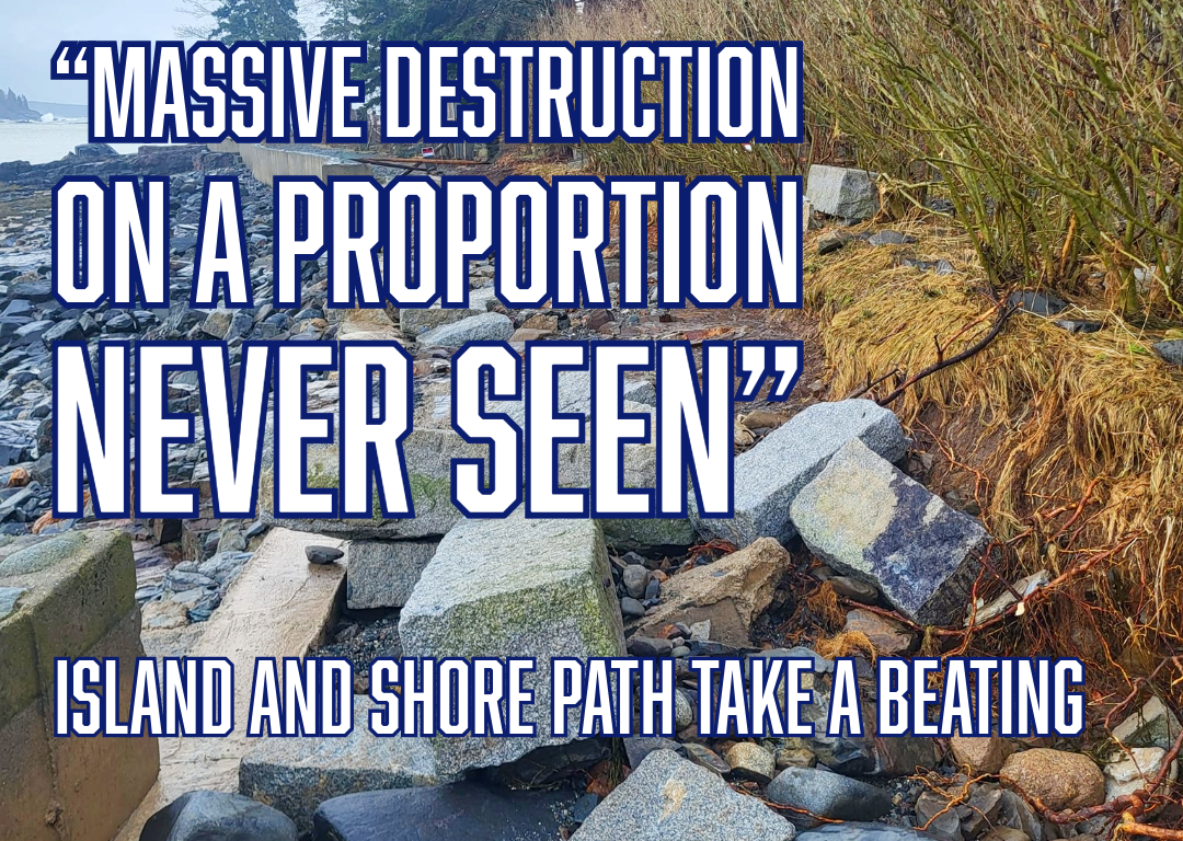
“Massive destruction on a proportion never seen”
Island and shore path take a beating.
CARRIE JONES
JAN 11, 2024

BAR HARBOR—Bar Harbor’s famous Shore Path is closed.
After significant damage to the path in yesterday’s mammoth storm, the path has been cordoned off to protect the public and prevent further erosion. Wednesday’s storm brought gusts of over 75 mph in the Down East region, moved a camp out to sea, and caused damage to multiple roads and structures throughout Mount Desert Island. It also left more than 14,000 Versant customers without electricity.
Its impact in Bar Harbor was heavily felt with some still assessing damages today.
“This is massive destruction on a proportion never seen before on the Shore Path in my lifetime,” said Bar Harbor Village Improvement Association President Dickie Cough. “It will take more money than we have to repair it all, so we will need to start raising money immediately.”
Massive portions of the path no longer exist. Nearby, the Bar Harbor Inn’s pier has a gawping hole in it. Damage to the Harborside Hotel and cruise ship tendering area and shops was also readily apparent as business owners assess damages.
video courtesy West Street Cafe
But the Shore Path is a different beast. It’s part of Bar Harbor’s lure and its history. Less than a mile long one way, it’s a staple for visitors and a major place of vacation photos and memories.
The Bar Harbor Village Improvement Association keeps the publicly accessible path clean and groomed so that people can visit Frenchman’s Bay without leaving the land. The Shore Path begins at the Bar Harbor Inn or the town’s Ells Pier and ends at Wayman Lane. Different property holders own different portions of the path.
According to the association’s website,
”This lovely walking path was made possible by the VIA working with the landowners who generously sacrificed their privacy so the public could enjoy this amazing walk. In return, the VIA accepts the responsibility and costs for maintaining the path and seawall improvements. Please do respect their property and privacy while enjoying this gem. ”The Shore Path dates to 1880. The VIA has made significant improvements to the gravel surface and stone retaining walls. We also added stone benches in 2012 and historic informational panels in 2013. The section of path between Agamont Park and Grant Park was recently widened from three feet to six feet to better accommodate current foot traffic.”
Throughout the year, tourists and locals stroll and saunter around a little point of land and past the inn along a gravel path that hugs the coast line. Toward town in the spring, there will be wild roses, fences on private property in various states of repair.
“This is the fourth damaging storm this winter and we’ve already talked with Harold MacQuinn Inc. about assessing the damage and prioritizing repairs,” Cough said. “Weather will play a role as to when major repairs can get started, as it will be necessary to replace entire sections of seawall. It’s also apparent the existing height of the seawall is no longer sufficient to keep the storms off the path so that must be addressed, too.”
“The path is closed until further notice ,” Cough said.
The organization’s board issued the following statement:
“The Bar Harbor Shore Path is on land that is privately owned by the abutting landowners. They have for years generously allowed the use of their land. The Shore Path is maintained by the Bar Harbor Village Improvement Association. “In light of today’s storm and the significant damage which has occurred to the shore path from the Bar Harbor Inn to Wayman Lane, and with consideration to public safety, the BHVIA has closed all access points, from the Town Pier, from Grant Park and from Hancock Street and Wayman Lane. “We would ask the public that for everyone’s safety, this closure be respected until further notice.”
During the January 10, Comprehensive Planning Committee meeting, Town Council Chair Valerie Peacock mentioned the town’s need to deal with such events as the storm that can damage roads and other infrastructure.
“I think we need to start thinking differently,” Peacock said about “planning for a different future of resilience” in places like Ells Pier, which was pummeled by storm surge and damaged.
Maine DOT’s Director of Communications Paul Merrill said the DOT has been focused on resilience efforts in recent years because of the changing climate.
“Those efforts involve planning for higher sea-level rise and upsizing culverts,” he said. Some of those efforts are detailed on the DOT’s site.
The costs of cleaning up properties on public and private lands is still being determined.
BAR HARBOR ROUTE 3/HULLS COVE/OCEANARIUM/ACADIA
The Bar Harbor Oceanarium and Education Center near the head of the island had significant flooding, too. Private videos show deep water forming waves throughout the property. The Oceanarium is expected to release photos and a statement later today.
“It’s flooded,” said a staff member on the uploaded video.
Plow trucks removed debris that washed up in Hull’s Cove, blocking the roadway, Wednesday morning.
In Acadia National Park, Sand Beach was covered with water and waves crashed up the access stairs. Nearby, Thunder Hole was filled with water, large rocks were tossed onto the Park Loop Road and there was some erosion. The Schoodic portion of the park was also heavily impacted by storm surge combined with wind and tide.
Isle au Haut, part of Acadia National Park, experienced a 95-mph gust.
The Tay , a schooner that wrecked in July 1911 and had been buried under sand dunes, came into the air on Wednesday after massive amounts of sand was washed away. Crew clung to the schooner’s mast during the storm that contributed to its sinking. One by one, they swam ashore, all surviving except for the cook, J. B. Whelpley.
As Acadia National Park’s website reads,
“The Tay quickly broke to pieces. Clinging on for dear life to the broken mast, the Tay’s crew waited till the tide went out so they could scramble to the safety of the sandy beach. The crew found refuge in the Satterlee Family’s summer home. A large portion of the Tay’s cargo, close to ninety thousand feet of spruce planks, was washed ashore by the waves. The lumber was salvaged by many local islanders as well as the Satterlee family, who built a boathouse with salvaged lumber to honor the shipwreck.”
Louise Satterlee was J.P. Morgan’s daughter.
The storm that did in the Tay also wrecked a catboat, pushing it up on Rodick Island. Another accounting of the wreck specified that its cargo was spruce shingles. According to the Bar Harbor Record, it was a southwest wind that broke the ninety-four feet long schooner that had been built in 1887.
SEAL HARBOR BEACH/LITTLE LONG POND AREA/ROUTE 3 AND OTHER ROADS
Route 3 by Little Long Pond in Mount Desert is closed. The sea wall was pounded down and swept both in and out during the storm.
Seawall in Southwest Harbor has closed. Peabody Drive in Northeast Harbor was closed. Route 3 in the Thompson Island area was down to one lane.
The Bernard wharf and dock had storm surge damage and is closed The Tremont Road in Tremont experienced serious flooding.
Seal Harbor Beach also did not fare well. The Rockefeller Boat House on Dodge Point Road had emergency response staging as a propane leak on the road necessitated attention. The road itself was shut down in sections.
According to the Schoodic Institute, “higher sea levels mean that storm waves and flooding are also higher. The worst case scenario of a storm arriving at the same time as a king tide occurred December 2022. A three-foot surge in water levels provided a glimpse of average sea level rises in the future.”
The water hit those marks on Wednesday.
SATURDAY’S STORM
Meteorologists predict another storm Saturday that also has high winds.
NEEDS YOUR HELP
If you have still images of the storm, please think of sending them to the MDI Historical Society. It needs your help. The Society is looking for images from the storm for a project they are doing with the Schoodic Institute on sea level change. They are particularly looking for images from today from the head of the island, Bass Harbor marsh, and Seal Cove/Pretty Marsh areas. Please send to [email protected] with info about when the image was taken/where the image was taken/who took the image.
WHAT TO DO IF YOU HAVE DAMAGE
From the maine coast fisherman’s association:.
Earlier today, we shared that individuals and businesses whose working waterfront or fishing businesses were impacted by the recent storm should share those impacts and losses with their local municipality. The response was so overwhelming that the Maine Emergency Management Agency has stepped in to help streamline the reporting process by providing an online survey to fill out instead of calling your local town hall . “It is imperative that individuals of private industry and privately owned commercial infrastructure who sustained property damage from the January 10th storm, including wharfs, floats, vessels, etc. document and report that damage.” Commissioner Keliher (Department of Marine Resources) HOW TO REPORT DAMAGE The online Initial Damage Assessment Survey can be found HERE . This is not an application for assistance nor a guarantee of financial assistance. Submission of damage information will help the State of Maine understand the extent of damage from the January 10th storm. Individuals who sustained damages to their primary residence are encouraged to document and report that damage by filling out the Individuals & Households Initial Damage Assessment Survey ( HERE ). MCFA will be updating our website and Facebook with information and links.
Contact Monique Coombs if you need assistance with the survey. [email protected]
FROM THE MAINE DEPARTMENT OF MARINE RESOURCES
Yesterday’s storm has resulted in unprecedented damage to property along Maine’s working waterfront. DMR is working closely with Governor Mills and the Maine Emergency Management Agency as we assess the extent of the damage to Maine’s coastline. DMR, with the support of the Maine Forest Service, will be conducting an aerial survey along the coast today, documenting the damage. It is imperative that individuals with damaged property from yesterday’s storm, including wharfs, floats, vessels, etc. document that damage, share that information with their local municipality, and ask their municipality to report documented damage to the appropriate Maine county emergency management agency . Please share this information with anyone on Maine’s working waterfront who may have experienced damage from this storm. In the meantime, please be aware of areas along the coast, both on land and on the water, where there may be hazards as a result of yesterday’s storm and proceed with caution. Also, please note that we have a similar storm coming this weekend with an even higher tide, so it’s clear that additional preparations will be needed. DMR will continue to evaluate this situation and will communicate updates from the Governor’s office and from MEMA as efforts to recover from this storm move forward.
LINKS FOR MORE INFORMATION
To donate to the Village Improvement Association
To donate to the Oceanarium
To donate to the MDI Historical Society
Storm Smashes Into MDI
CARRIE JONES AND SHAUN FARRAR
Read full story
Bar Harbor’s Shore Path
Bar Harbor Story is a mostly self-supported publication and covering this storm did us in a bit this week, putting us behind on our paying work, so we might be a bit slower for a couple of days. To receive new posts and support our work, consider becoming a free or paid subscriber. Thanks for being here with us and caring about Bar Harbor, too.
Type your email…
Make a one-time donation
Make a monthly donation, make a yearly donation.
Choose an amount
Or enter a custom amount
Your contribution is appreciated.
Share this:
3 thoughts on “ “massive destruction on a proportion never seen” ”.
Thank you for your incredible coverage. We all appreciate your efforts. Betsy McCallum
Like Liked by 1 person
God bless you all. My niece livesin Bar Harbor and we’re all praying for you!
Thank you so much, Iris. That’s very kind of you.
Leave a comment Cancel reply

- Already have a WordPress.com account? Log in now.
- Subscribe Subscribed
- Copy shortlink
- Report this content
- View post in Reader
- Manage subscriptions
- Collapse this bar
Watch CBS News
Redondo Beach sees huge waves as rain, high surf cause flooding in coastal communities
By KCAL-News Staff
Updated on: January 6, 2023 / 8:00 AM PST / KCAL News
The Southland coast was among the many regions battered by rain when both an atmospheric river and bomb cyclone hit California overnight from Wednesday to Thursday.
As the storm moves out of the area, flooding concerns remain high however with high surf expected come Friday.
At 11 p.m. Thursday evening, huge waves could be seen crashing on the shore in Redondo Beach, causing considerable flooding on the beach as it surpassed the seawalls.
The unique combination of a full moon and the lingering effects of the atmospheric river, bomb cyclone combination caused weather officials to issue a high tide warning for Southern California coasts.
They estimate that the King Tides could cause massive waves anywhere between 12 and 14 feet. As a result, the Redondo Beach Pier is closed until Sunday for public safety. The Yacht Club in the area was also closed until Sunday.
Police closed several roads close to the beach due to flooding, which are expected to remain shut down until they can assess the situation in the morning.
The high tide warning lasted until 6 p.m. on Friday.
Some roadways across the Southland became overrun Friday with water and debris, forcing some street and freeway lane closures. But the system dropped far less rain than originally expected as it quickly moved through the area.
Friday morning around 9:20 a.m., Southbound Pacific Coast Highway was closed between Warner Avenue and Seapoint Street in Huntington Beach due to flooding, according to the city.
Later in the day, the waves seemed to have mellowed down some, with spectators able to walk along the shore and witness the waves a little closer than the night prior.
Some light flooding occurred in beach parking lots, though precautions taken by residents seemed to have curbed major impact thus far.
City officials implemented their annual sand berm on the beach in hopes of protecting homes and businesses along the shore.
Lifeguards, volunteers and city workers were busy overnight filling sandbags and building additional berms in problem areas, taking the extra precautions after considerable flooding in September of last year, when a rare hurricane, Hurricane Kay, hit the coast.
Even with the preparations, some water began to seep into the Beach House restaurant.
"My partners and I, we thought, 'What are we gonna do?'" said Rosie Ritchie, one of the owning partners of the eatery. "We know the berms are there, but they didn't really do a good job last time."
Their patio was still under construction during September's hurricane, pushing back their grand opening by two months.
"The journey has been long," Ritchie said. "We were so excited to open and we did."
The threat of additional flooding has her and many others on edge in Seal Beach and surrounding areas, with King Tides expected heading into the weekend.

The KCAL News Staff is a group of experienced journalists who bring you the content on KCALNews.com and CBSLA.com.
Featured Local Savings
More from cbs news.

Rain, thunderstorms possible Monday afternoon

High-speed chase ends as woman drives into ocean in Marina del Rey

Construction on LAX's People Mover creates major traffic snarl

Dan Monson leads Long Beach State to the tourney, despite getting fired days earlier
- ABC7 Bay Area 24/7 live stream Watch Now
- Watch ABC7 newscasts on demand Full Story
Storm damage: Here's before-and-after look at hardest-hit areas in Capitola, Santa Cruz

SANTA CRUZ, Calif. (KGO) -- One of the hardest-hit areas from Wednesday's devastating storm was the Santa Cruz County coastline.
Video showed the storm surge destroying a part of the Capitola Wharf and washing up massive logs on Santa Cruz beach.
But to really get a sense of how big the waves were, you need to look at what it normally looks like.
TIMELINE: 'Parade of storms' lined up for Bay Area as bomb cyclone recovery continues
ABC7 News found a few spots in the Santa Cruz area and compared a before shot on Google Maps to the videos gathered during Thursday's epic storm.
SANTA CRUZ - East Cliff Drive
We found this unbelievable video from a house next to Moran Lake Beach. During normal conditions, the water sits about 150 feet from East Cliff Drive.
But in the video from the storm, a massive wave can be seen rolling completely over that 150 feet, going over East Cliff Drive, and flooding into the neighboring Moran Lake.
The home that sits on the Southern part of the beach was also badly damaged, as the wave in the video smashed through the waterfront part of the house, went through the entire home, and came out of the garage.
CAPITOLA WHARF
This iconic Capitola landmark usually stands about 20 feet above the water (depending on the tide) as seen in the before image from Google Maps.
But during the height of the high surf, the tops of the waves were regularly slamming into the upper platform of the wharf.
Ultimately, the powerful waves, destroyed a large section of the wharf, making it unusable and in need of major repairs.
RELATED: From washed-away piers to devastating flooding, here's a look at storm damage around Bay Area
CAPITOLA - Soquel Creek
Before images of this creek, show it calmly flowing into the ocean at Capitola State Beach.
A number of restaurants along the Esplanade look out onto this creek, including Margaritaville, Capitola Bar & Grill, Paradise Beach Grille, and the Sand Bar Capitola.
These restaurants normally sit around 400 feet from the ocean's edge and 5-10 feet above the creek, but the video from Thursday show waves crashing all the way up the creek and washing into and over the outdoor patios of these restaurants.
APTOS PIER - Seacliff State Beach
This pier used to connect to the iconic '"Cement Ship" until the landmark was damaged in previous storms.
Before images of the pier, show that it also stood about 20 feet above the water (depending on the tide).
But videos from Thursday show waves rolling over the top of the pier and ultimately demolishing a huge chunk of the wooden structure.
Watch the latest AccuWeather forecast and take a look at recent weather stories and videos.

If you're on the ABC7 News app, click here to watch live
Related Topics
- SANTA CRUZ COUNTY
- STORM DAMAGE
- STORM RECOVERY
Top Stories

Baby, parents ID'd in fatal SF bus stop crash: Brazilian Consulate

Burglary suspects involved in deadly wrong-way crash near Bay Bridge
- 26 minutes ago

Armed suspect fatally shot by Campbell police officer, authorities say
- 34 minutes ago

SF mayor calls SFPD to release video in fatal attack of Chinese woman

Oakland to intensify crime crackdown near Hegenberger corridor
3 things to watch for in Tuesday's primaries
Mega Millions is now up to $893M ahead of Tuesday's drawing
2 sought after German Shephard puppy shot in head in SJ: police
- Skip to Nav
- Skip to Main
- Skip to Footer
Severe Bay Area Storm Brings Historic Winds, Regional Flooding and Power Outages
Please try again

Updated 12 p.m. Tuesday
At least three people in Northern California were killed in the massive storm that slammed the region on Sunday and Monday before moving farther south, officials said.
An 82-year-old man in Yuba City, north of Sacramento, was found crushed beneath a redwood tree in his yard on Monday, the California Governor’s Office of Emergency Services confirmed. Investigators said the man, identified as David Gomes , appeared to be using a ladder in an attempt to clear the damaged tree away from his home when it fell on him.
Also on Monday, a 45-year-old man in Boulder Creek, in the Santa Cruz mountains, was killed when a tree fell on his home, officials confirmed. The man, Robert Brainard III, was pronounced dead at the scene, the Santa Cruz Sentinel reported.
And on Sunday, Chad Ensey, a 41-year-old man in the Sacramento suburb of Carmichael, also died after a tree fell on him in his backyard, the San Francisco Chronicle reported.
The intense atmospheric river-fueled storm that pummeled the region with heavy rainfall and hurricane-force winds — nearing or topping 100 mph in a handful of mountainous Bay Area locations — left hundreds of thousands of homes and businesses without power on Sunday and into Monday. As of 10 a.m. Tuesday, more than 63,000 homes in the Bay Area — including upward of 27,000 in the North Bay — were still in the dark, according to PG&E.
With the storm expected to wreak even more havoc in already-saturated Southern California, Gov. Gavin Newsom on Saturday declared a state of emergency for Los Angeles, Orange, Riverside, San Bernardino, San Diego, San Luis Obispo, Santa Barbara and Ventura counties, which allows the state to mobilize the National Guard for emergency response if necessary. The Office of Emergency Services activated its operations center and positioned thousands of personnel and equipment in areas throughout the region most at risk.
Updated 7:50 p.m. Sunday
As a massive storm continues to roll over the region, the National Weather Service said thunderstorms, lightning and hail are still impacting the Bay Area Sunday evening, with power outages impacting more than 700,000 customers.
Scattered thunderstorms and showers will last through the night until most of the rain has passed by Monday morning.
“There still could be some residual flooding on the roadways with the soils being saturated,” said NWS meteorologist Sarah McCorkle. “We could still see some downed trees, but overall, things should calm down by tomorrow morning.”
According to the state Office of Emergency Services, in the last few hours, Santa Clara County has seen the number of customers in the dark more than quadruple, to nearly 109,000. Close to 80,000 customers are without power across the North Bay.
San Mateo power outages have more than tripled in that time frame to over 74,000.
“We’ve got hundreds of crews out there responding to these outages, and it’s all storm-related,” said Jeff Smith with PG&E. “You know there’s a lot of heavy winds, and winds can knock power lines together and sometimes cause trees and branches to get into power lines.”
High wind warnings and wind advisories remain in effect through Sunday at 10 p.m. as wind speeds diminish this evening except at higher peaks.
“The NWS Storm Prediction Center in northern Oklahoma, usually the place that issues severe thunderstorm and tornado watches, just highlighted this region as having at least a slight chance of generating tornadic thunderstorms in the next one to two hours,” UCLA climate scientist Daniel Swain said on Sunday, pointing out that the extreme rain and intense winds stretched from Santa Cruz to San Jose.
Meteorologists with the NWS Bay Area office explained there’s a 5% chance they’ll issue a tornado watch.
Water officials in the South Bay said the worst of today’s storms have passed — without flooding along the Guadalupe River in San Jose, which city officials thought could overflow. Water levels reached above seven feet around noon but have since declined. That’s short of the 9-and-a-half feet the National Weather Service defines as flood stage for the river.
Valley Water spokesman Matt Keller says that’s good news for nearby residents.
“You know, if the forecast would have delivered what it was, they would have seen flooding in that area,” he said. “But because, you know, Mother Nature could do what Mother Nature does, it’s as much as we like to forecast, it can still be unpredictable. And, we did not see the impacts that we were expecting.”
The city of San José remains under a wind advisory with gusts expected up to 60 miles per hour.
Updated 4:30 p.m. Sunday
A community center in San José will remain open today for unhoused residents seeking shelter from the wet weather. The Roosevelt Community Center on Santa Clara Street will accept walk-ins today — with space for 90 individuals.
On Saturday, the city ordered an evacuation for unhoused residents living along the banks of the Guadalupe River, which ultimately avoided flooding. San José Mayor Matt Mahan says city police broadcast a message over a loudspeaker warning people to leave the river banks.
“It’s the most efficient tool we have for letting homeless residents living along the waterways know that there’s a risk and that they need to relocate,” he said.
After Saturday’s evacuation order, more than 40 people stayed at the Roosevelt Community Center.
“Right now, it’s just the wind that I’m keeping an eye on because we could have more trees and power lines down and more power outages,” Mahan said.
In Oakland on Sunday, Eugene Jacobs, who has been unhoused since 2017, tied a tarp over his tent under the 980 overpass at Sycamore St. The Oakland native said he lives in a tent just a few hundred feet away.
“My whole front door and back door have been torn off,’ he said. “It’s been hard to deal with, but as long as you stay under this underpass right here when you’re homeless, you stay dry.”
While the Bay Area is still experiencing the lingering wind and rain, much of the effects have yet to hit Southern California, but Swain says that will change as the day continues with flash flood warnings from Santa Barbara south.
“If you’re in Los Angeles and San Diego, you’re still saying ‘what storm?’ because it is essentially raining lightly on the west side of LA with partly cloudy conditions or sunny conditions relatively warm, east and south of that, but just wait, it is coming,” he said.
Original story

The Bay Area is preparing for extreme weather conditions, flooding, massive waves, downed trees and power outages as an atmospheric river-boosted storm sweeps across the region. The National Weather Service expects the storm to last through Monday and could be stronger and more intense than any storm this year.
NWS meteorologists said Sunday up to three inches of rain could fall on the Santa Clara area, which could be the hardest hit this afternoon and evening. NWS expects up to five inches of rain on the coastal side of the Santa Cruz Mountains.
“The heavier rain is expected this afternoon when there’ll be heavier downpours and thunderstorms,” said NWS meteorologist Sarah McCorkle.

San José has issued a mandatory evacuation along four creeks — the Coyote, Los Gatos, Penitencia and Ross Creeks — and the Guadalupe River. The city has alerted unhoused residents that the waterways are likely to rise. The river forecast center with NWS now predicts the Guadalupe River will peak at 2 p.m. today above the flood stage.
“Please do not be anywhere near the waterway and be aware while driving or parked vehicles,” said San José Mayor Matt Mahan in a Saturday press conference.
Power outages and flight delays
More than 120,000 customers from Sonoma to Monterrey Counties are without power , according to the PowerOutage site, including residences from Rohnert Park, Tiburon, San Francisco, Pacifica, Newark, and San José.
The greatest concentration of power outages in the region is in the South Bay. Around 23,000 PG&E customers are without power in the San José, Cupertino and Sunnyvale areas. In the North Bay, there are around 12,000 PG&E customers without power. PG&E has hundreds of crews responding to storm-related outages across the Bay Area.
Bay Area airports are seeing a rise in delays and cancellations as heavy wind and rain move through the region. The San Francisco Chronicle reported San Francisco International Airport temporarily delayed landings this morning and rerouted two flights to Oakland airport.
Kaley Skantz, public information officer at Oakland International Airport, said the airport has had 18 departure delays and two cancellations.
“We do recommend checking flight status with your airline before coming to the airport just to ensure that you have the most recent information about your travel itinerary,” she said.
In San Jose, officials with Minetta International Airport said they had 57 delays and two cancellations so far today, which a spokesperson says is higher than normal, but not out of the ordinary for a stormy day.
Along the San Mateo coastline, waves crashing on the shore are 25 feet tall, according to San Mateo County Supervisor Ray Mueller.
“Right now, Highway 1 is completely closed south of Pescadero due to downed powerlines in roads,” he said.

Strong winds
The storm, lasting through Monday, is also expected to bring 30-80 miles per hour of winds across the region as well as nuisance flooding. Weather officials expect hurricane-force winds off the Monterey Coast.
“For the first time in their history, there’s a hurricane-force wind warning for the offshore waters of Monterey County and that does not mean that the storm itself is a true hurricane,” said UCLA climate scientist Daniel Swain. “In most places, the strongest winds haven’t occurred yet.”
Swain said the storm, with its tail reaching past Hawaii, is developing in place and the worst of the precipitation is yet to come. As the storm heads south, he said, water spouts or tornadoes are possible.
“It’s far from over yet and in some respects, the storm won’t peak until this afternoon or evening,” he said.
Potential flooding
Regarding flooding, Swain said he doesn’t think the flood risk will be widespread in the Bay Area.
“This is not an epic flood event for Northern California because it isn’t in the right position for the storm to see high rainfall totals, but it could be for Southern California,” he said.
After the storm sweeps over the Bay Area, Swain expects it to hit Southern California, where flash flooding could inundate the region and a few evacuation orders are already in place.
“This is just going to increasingly align across Southern California for the next day and does bring for flooding risk later on across Southern California,” he said.
As for the Sierra Nevada snowpack, Swan said this storm will likely give it a “kickstart” and could be the biggest snow event of the year so far.
Emergency services
According to San José’s official website , Roosevelt Community Center (901 East Santa Clara Street) will serve as an extended Overnight Warming Location (OWL). Walk-ins will be accepted at the OWL today and Monday, and pets are welcome. Additional information about Santa Clara County’s warming locations can be found here .
KQED’s Annelise Finney, Rachael Vasquez, Lakshmi Sarah and Beth LaBerge contributed reporting to this story.
To learn more about how we use your information, please read our privacy policy.
- International
Atmospheric river lashes California with heavy rain and wind
By Mary Gilbert, Antoinette Radford, Eric Zerkel, Elise Hammond , Zoe Sottile, Amir Vera , Kathleen Magramo and Deva Lee, CNN
Our live coverage for the day has ended. Follow the latest weather news here or read through the updates below.
Here's what to expect for Tuesday's morning commute
From CNN's Robert Shackelford

The worst of the storm occurred on Monday, but rainfall is still forecast for major cities across California.
Here's what to expect during the morning commute on Tuesday:
LOS ANGELES
- Alert: Flood watch until 4 p.m. PT
- Peak rainfall: During the morning commute on Tuesday
- Additional rainfall total: 1-2 inches
- Tuesday morning forecast: Rainfall will be ongoing, and isolated pockets will be heavy at times. Water should still be on roadways and driving is not advised.
SAN FRANCISCO
- Alert: Coastal flood advisory from 6 a.m. PT to 11 a.m. PT on Saturday
- Rainfall: Rainfall has largely ended for the area.
- Tuesday morning forecast: Rainfall will have largely subsided but isolated pockets of roadways could still have standing water.
- Alert: Flood watch until 6 a.m. PT
- Peak rainfall begin/end: Until 3 a.m. PT
- Rainfall total: 1-2 inches
- Tuesday morning forecast: Rainfall will peak in the hours leading up to the morning commute, so water should be on roadways and driving is not advised.
- Alert: Flood watch until 4 a.m. PT
- Peak rainfall begin/end: Now until 2 a.m. PT
- Rainfall total: 1-2 inches
- Tuesday morning forecast: Rainfall peaking in the hours leading up to the morning commute, so water could be on roadways and travel could be delayed.
- No alerts at this time
- Rainfall has largely ended for the area
- Tuesday morning forecast: Rainfall will have ended but isolated pockets of standing water could still slow the morning commute.
- Alert: Coastal flood advisory from 6 a.m. to noon PT
- Peak rainfall begin/end : Now until 3 a.m. PT
- Rainfall total: Under an inch
- Tuesday morning forecast: Rainfall will peak in the hours leading up to the morning commute, so water could still be on roadways.
Storm slams Downtown Los Angeles with 75% of its annual rainfall — and it's only February

As a powerful atmospheric river continues to impact Southern California, cities like Los Angeles have seen an incredible start to their year in terms of rainfall.
Since January 1, the weather station has received 10.72 inches through Monday evening PST — equivalent to is about 75% of the yearly average rainfall.
For comparison, the average yearly rainfall for downtown Los Angeles is 14.25 inches.
Forecast: It is still raining across Southern California. The Weather Prediction Center (WPC) has issued a slight risk for excessive rainfall, or a level 2 of 4, for Southern California, including downtown Los Angeles, for Tuesday.
A marginal risk for excessive rainfall, level 1 of 4, remains over parts of Southern California for Wednesday.
Pup "eager to reunite with his human" after owner rescued from raging Los Angeles river
From CNN’s Amanda Musa
The Los Angeles Fire Department has shared photos of the dog belonging to a man who had to be rescued from a river on Monday after jumping in to save his pet.
The pet owner was lifted out of the river by helicopter while the dog managed to swim to safety and escape the rapids, the LAFD said.
“This pup was happy to be alive, and eager to reunite with his human,” LAFD said in a post on X on Monday night.
Heavier rainfall moves into San Diego
Flash flooding is possible for San Diego County in the coming hours as heavier rainfall reaches the area, according to a warning from the National Oceanic and Atmospheric Administration's Weather Prediction Center.
A flash flood warning remains in effect for Riverside County, southeastern Orange County and northwestern San Diego County for the next hour or so, with more flash flooding possible as the rainfall picks up.
San Diego County may see 0.25 to 0.75 inches of rainfall per hour, with rainfall totals accumulating between 1 and 2 inches.
Moderate risk: A moderate risk for excessive rainfall, or a level 3 of 4, remains in effect for the couple of hours across Southern California before dropping to a slight risk for excessive rainfall, or a level 2 of 4, for the day on Tuesday.
Flood watches have dropped across Northern California. And, the total population under flood watches across Central California, Southern California and parts of Arizona and Nevada is over 30 million people.
Deadly atmospheric river unleashes record rainfall in California. Here's what to know

A powerful atmospheric river-fueled storm is hovering above Southern California, unleashing torrential rain and floods across the metro-Los Angeles area.
The slow-moving storm has also turned deadly, with at least two confirmed deaths as trees topple over homes and streets. Intense flooding and mudslides have also damaged many homes in the state.
The worst of the storm’s rainfall will slowly shift south throughout the day, with the threat shifting from Los Angeles to the San Diego area by Monday evening.
Here's what to know:
- Over 10 inches of rain: Portions of Los Angeles County have accumulated more than 10 inches of rain since Sunday, raising the risk of flash floods and mudslides in the inundated area. Some areas reached nearly 1 foot of rainfall, with Bel Air seeing 11.68 inches of rain and Sepulveda Canyon accumulating 11.51 inches of water, according to the National Weather Service .
- Storm-related deaths: At least two California residents have died from falling trees in the powerful storm. Those killed include a 41-year-old man from Sacramento County , a 45-year-old Santa Cruz County resident .
- Snow piles up in California mountains: Heavy snowfall associated with the atmospheric river-fueled storm system over California has been helping with the snowpack accumulation in the Sierra Nevada mountains, which is crucial to the water supply. Heavy snow measuring some 2-feet deep is burying the state's mountains — as of February 5, the California snowpack is at 72% of normal conditions, according to the National Weather Service.
- Unhoused in the storm: One hundred unhoused people were evacuated from a tiny home complex Monday due to flooding, Los Angeles Mayor Karen Bass said during a news conference. She adds that evacuations are ongoing.
- Biden makes surprise comments: President Joe Biden unexpectedly made comments via phone during a news conference, saying he and California Gov. Gavin Newsom are working closely to get resources mobilized.
- Highways and roads closed: Several major roads remain closed due to storm damage and debris pile up. Benedict Canyon Drive in the Beverly Hills area is “impassable” between Sunset Boulevard and Mulholland Drive Monday afternoon, the Los Angeles Department of Transportation said on X. The storm also chipped off parts of the Pacific Coast Highway in Ventura County, which now remains closed.
Downtown Los Angeles sees one of its wettest two-day periods as daily rainfall records hit Southern California

The latest Weather Prediction Center (WPC) reports show the impact of the powerful storm bringing record-setting precipitation in parts of California.
Here are some notable rainfall totals over the latest two-day period, according to the WPC:
- Bel Air Hotel: 11.64 inches
- Sepulveda Canyon: 11.64 inches
- Stunt Ranch: 11.07 inches
- Beverly Hills: 7.95 inches
- Downtown Los Angeles : 7.01 inches
Downtown Los Angeles's 7.01 inches in two days is the area's third-wettest two-day period on record as of Sunday.
Here are the top five wettest two-day periods for Downtown Los Angeles:
- 7.98” ending Jan 1, 1934
- 7.44” ending Jan 26, 1956
- 7.01” ongoing since yesterday
- 6.51” ending Dec 29, 2004
- 6.36” ending March 2, 1938
Excessive rainfall warnings: The excessive rainfall across Southern California has been downgraded to a moderate risk, or a level 3 of 4, with the latest update from the WPC.
Over 16 million people remain under the moderate risk area, including Downtown Los Angeles, as the rainfall total is likely to keep rising.
Daily rainfall records have also been shattered on Monday in parts of Southern California, according to data from the National Weather Service:
- Downtown Los Angeles: 2.76 inches (old record 2.3 inches set in 1901)
- Los Angeles International Airport : 2.37 inches (old record 1.42 inches set in 1978)
- Long Beach Airport: 2.31 inches (old record 1.4 inches set in 1978)
- Bob Hope Airport: 2.08 inches (old record 1.46 inches set in 2009)
- Palmdale Regional Airport : 1.37 inches (old record 0.61 inches set in 1948)
Flood watches remain for around 35 million people across the state and may be allowed to expire across Central California Tuesday morning.
Pacific Coast Highway closed in several locations due to storm damage
From CNN's Taylor Romine

The Pacific Coast Highway along California's coast is closed in at least two places after storm damage made it unsafe, the California Department of Transportation ( Caltrans ) said Monday.
In Ventura County, which is directly above Los Angeles County, the highway is closed in both directions from Las Posas Road to Sycamore Canyon Road "due to washed out road from storm erosion," Caltrans District 7 said in a post on X .
The highway is also closed both ways in Monterey County near Limekiln State Park due to a landslide on the road, Caltrans District 5 said in a post on X .
Flight delays and cancellations mount at major California airports

As a powerful atmospheric river-fueled storm continues to bring heavy rain and gusty winds slamming California, flight delays have increased across major state airports.
Here are the latest flight cancellations and delays into and out of major airports for the last 48 hours (as of 7:40 p.m. PT), according to FlightAware :
Los Angeles International Airport (LAX)
- Canceled: 60+
- Delayed: 1,100+
San Francisco International Airport (SFO)
- Canceled: 255+
- Delayed: 840+
Sacramento International Airport (SMF)
- Canceled: 45+
- Delayed: 120+
San Diego International Airport (SAN)
- Canceled: 30+
- Delayed: 320+
Metro Oakland International Airport (OAK)
- Canceled: 35+
- Delayed: 145+
Please enable JavaScript for a better experience.
3 dead as storm pummels California, causing flooding and dozens of mudslides in L.A. area
What to know as a severe storm system moves into california.
- The severe storm system began moving through California on Sunday, marking the start of what's expected to be days of heavy rain and snow.
- About 38 million people are covered by flood alerts because of a weather system that the National Weather Service said could be "potentially historic."
- At least three people have died in fallen tree incidents associated with the severe weather.
- About 250,000 homes and businesses are without power in California, mostly in the northern and central parts of the state.
- Heavy rain led to mandatory evacuations for parts of Santa Barbara and Ventura counties Sunday, and firefighters rescued 16 people from a single street in Los Angeles as mudslides caused havoc. The orders were canceled for Santa Barbara County and downgraded for Ventura County this afternoon.
- NBC News' Liz Kreutz, Dana Griffin, Elwyn Lopez and Sam Brock are reporting from California.
Flood watch remains for Los Angeles area until Tuesday afternoon
Phil Helsel
While officials have said the heaviest part of the storm is over, the Los Angeles area remained under a risk of significant flooding through 4 p.m. tomorrow, according to forecasters.
More than 7 inches of rain fell in downtown Los Angeles, and some areas got 11 inches. The Los Angeles region was under a flood watch.
The slow-moving storm will stay over the region through tomorrow or even Wednesday, the National Weather Service said. Freeways could still flood, creating dangerous conditions and mudslides, and other debris flows remain a threat in hillside communities and around burn areas, the agency said.
“While the risk for flash flooding has decreased slightly since the Sunday night peak and most of the additional rain will be light to moderate in intensity, the threat for additional enhancement with heavy downpours and rain rates of 0.5 to 1.0 inches per hour remains,” the weather service said in a statement .
Rain still to fall in San Diego area tomorrow
The rain that has hit Southern California and San Diego will not be over when drivers go to work tomorrow, forecasters said.
“Tomorrow on Tuesday, especially during the commute, it’s still going to be raining. And then the storm is not over with Tuesday afternoon,” National Weather Service Meteorologist Alex Tardy said in a video update this afternoon.
Thunderstorms could be possible, and off-and-on rain will fall in the area through Thursday, Tardy said.
San Onofre Beach in northern San Diego County, closer to Los Angeles, got around 4 inches of rain over two days, the weather service said . Oceanside got a little more than 2 inches. Rainfall totals in San Diego through tomorrow night could be 2 inches, according to the weather service.
More than 250,000 customers without power in California
While the rain has eased in some parts of California, more than 250,000 customers in the state remained without electricity tonight, according to tracking website poweroutage.us .
Many of those were in Northern California and near the San Francisco Bay Area as of 8 p.m. Earlier today, around 350,000 customers had been reported without power. Customers are the number of homes and businesses, and not the same as the number of people affected.
Pacific Gas & Electric called the storm, in the terms of number of outages, among the most damaging single-day weather events on record. High winds knocked down trees or threw other objects into power lines, the company said. It said it had around 3,000 people working on restoration efforts.
Firefighters rescue woman in San Bernardino
Anthony Correia
Firefighters rescued a woman from a homeless encampment that became surrounded by floodwater in the Santa Ana River during a rainstorm in San Bernardino today.

Parts of Los Angeles got more than 11 inches of rain
A little more than 11 inches of rain had fallen in the Bel Air section of Los Angeles as of this afternoon, the National Weather Service said.
Sepulveda Canyon also had gotten more than 11 inches of rain as of 4:30 p.m. local time, as had part of Topanga, the NWS said.
Downtown Los Angeles got more than 7 inches of rain, the weather service said in a statement , and Beverly Hills got almost 8 inches.
In the San Francisco Bay Area, winds lashed the region over the weekend. The top wind report there was at Pablo Point, at 102 mph. Point Reyes, north of San Francisco, recorded 89 mph, the weather service for the region said .
Santa Barbara Airport reopens after flooding
Santa Barbara Airport reopened earlier today, after “significant flooding" occurred at the airfield. The airport resumed normal operations at 1 p.m. local time, it said.
A flood advisory remained in effect until 12:45 a.m. overnight, the National Weather Service said. Moderate and locally heavy rain could return there this evening, the agency said.
A flood watch was in place until 4 p.m. tomorrow.
Risk of additional landslides in Los Angeles remains ‘very high’
Even if the rain appears to slacken following 6 to 11 inches that have fallen in the Los Angeles area, it will take very little to cause additional mudslides and other debris flows, a National Weather Service meteorologist warned this evening.
Ariel Cohen, the meteorologist in charge of the weather service office for Los Angeles, said that the storms were historic and that it was “one of the wettest storm systems to impact the greater Los Angeles area since the history of records of weather have been made, going back to the 1870s.”
Light to moderate rain will continue to intermittently affect the Los Angeles area over the next several hours, Cohen said at a news conference around 5:30 p.m.
“The ground is extremely saturated — supersaturated. It’s not able to hold any additional water before sliding,” Cohen said. “It’s not going to take much rain for additional landslides, mudslides, rockslides and other debris flows to occur.”
“The risk for additional landslides remains very high, and everyone needs to remain at a high state of readiness as we head through the overnight hours,” he said.
Biden via phone tells L.A., ‘We’ll get any help on the way as soon as you guys request it’
In a cellphone call during a news conference in Los Angeles tonight, President Joe Biden said that the federal government would provide whatever assistance is needed following a major storm that caused mudslides.
Los Angeles Mayor Karen Bass held the phone to a microphone during the news conference, which had begun before the call.
“We’ll get any help on the way as soon as you guys request it,” Biden said. "So just let me know. That's why I'm calling."
Biden said he also had just spoken with California Gov. Gavin Newsom. Biden said the Federal Emergency Management Agency was well-positioned to provide assistance.
Bass said earlier that she also spoke with Vice President Kamala Harris, who represented California in the Senate.
‘Tough day’ for Los Angeles, mayor says
The storms that have pounded Los Angeles and caused mudslides has affected people all over the city, including around 100 unhoused people living in a tiny home community, the mayor said.
The people in that community, which flooded, were being moved to a nearby shelter, Mayor Karen Bass said.
There have been more than 120 mudslides and debris flows in the city because of the rain that has saturated hillsides, Los Angeles Fire Chief Kristin Crowley said this evening. Around 6 to 11 inches of rain has fallen over the region, she said.
“As this storm continues, there are many water-soaked hillsides that have the potential to slide,” Crowley said.
Bass said some homeowners have been devastated by the damage caused by mudslides. “This has been a tough day for our city, a tough day for Angelenos,” she said.
She added that people should remain off the roads and that the weather situation is not over.
Firefighters airlift man who jumped into rushing river to save dog
Return of rain extends flood advisories in ventura, l.a. counties.
The return of rain to parts of Southern California, already drenched by heavy precipitation, prompted the extensions of flood advisories for Ventura and Los Angeles counties, forecasters said.
The flood advisories for both were extended until 9 p.m. local time, the National Weather Service office for the region said on X.
4 people found safe after avalanche in Nevada, authorities say
Four people were found safe after an avalanche north of Las Vegas, authorities said today.
The avalanche was reported in Lee Canyon, about 50 miles northwest of downtown Las Vegas, Clark County officials said.
Las Vegas police said on X the avalanche triggered a search-and-rescue effort after “several” people were reported missing. Police said later that four people were reported missing.
“Everyone has been located and is safe. We are currently assisting people off the mountain,” police said.
The Lee Canyon ski resort area has recorded 11½ inches of snow in the last 24 hours, according to its website.
The storm system that has dumped snow in the area is the same one impacting California today. The area has also received nearly 3 feet of snow in the last week thanks to two atmospheric rivers .
Traffic held in Sierra Nevada after spinouts on Donner Summit
The California Highway Patrol this afternoon was temporarily holding traffic on parts of Interstate 80 after “multiple spin outs over Donner Summit,” the agency’s Truckee office said .
Traffic was being held eastbound at Cisco, the CHP said.
It was snowing in the Donner Summit area this afternoon, according to the National Weather Service. In a first storm, over a foot of new snow had fallen in that area as of Saturday morning, the agency has said. The area was under a winter watch until 10 o’clock tonight.
The summit and pass are named after the famous Donner-Reed migrant party, which became stranded in the snow by Truckee Lake in 1846. Some of them ate the dead to survive.
Los Angeles mayor warns people to stay inside, says ‘crisis is not over’
LOS ANGELES — Standing near the aftermath of a mudslide that damaged homes and destroyed vehicles, L.A. Mayor Karen Bass urged residents to stay home this afternoon.
“Even when the rains die down, there’s still possibilities of significant damage,” Bass said as she toured damage in the Studio City area. “And we want people to, one, stay inside. This crisis is not over with yet.”
A debris flow last night on Lockridge Road significantly damaged two homes, the Los Angeles Fire Department said. In all. nine homes were evacuated, and there were no injuries. Bass pointed to two cars that were destroyed.
Fire Chief Kristin Crowley said: "This is still an active storm event. You can see the running water and how much power can come behind this."
Outages among the worst for a single-day storm, California utility says
The chief operating officer of California utility Pacific Gas & Electric said the storm that hit the state yesterday was one of the most damaging single-day storms on record in terms of outages.
Sumeet Singh said the storm that hit its service area, which covers a huge area of the state from Northern to near Southern California, yesterday was “intense.”
“In terms of outage totals, this was one of the top three most damaging single day storms on record,” he said.
As of 9 a.m. today, about 440,000 of the utility's 5.5 million electric customers were without service, Singh said.
Wind gusts in Marin and Santa Clara counties, which are in the San Francisco Bay Area, and in Kern County, north of Los Angeles, were higher than 80 mph, he said.
“The strong winds caused trees and other objects to fly into our equipment and take out power,” Singh said.
San Francisco Mayor London Breed said this afternoon that the worst of the storm has passed but that crews were still clearing debris and assessing damage.
Climate change most likely intensified rainfall, UCLA scientist says
Climate change is warming the atmosphere and the ocean, and both dynamics most likely contributed to a more intense atmospheric river storm’s battering Los Angeles today, said Daniel Swain, a climate scientist at UCLA and the National Center for Atmospheric Research.
Atmospheric rivers are streams of water vapor in the sky. Swain said the moisture for this storm system originated about 1,000 miles south of Hawaii.
“In a warming atmosphere and as oceans warm along with the atmosphere, the ceiling on how intense atmospheric rivers can become and the ceiling on how intense precipitation can become increases pretty rapidly with warming,” Swain said in a YouTube briefing . “There’s fingerprints of human-caused warming all over events like this.”
California has warmed by more than 3 degrees Fahrenheit since preindustrial times, and Swain said the atmosphere can hold 3% to 4% more water vapor for every degree Fahrenheit of warming.
Ocean temperatures off California have been 2 to 5 degrees Fahrenheit above average this season, and that additional heat has most likely boosted the storm and contributed to intense rainfall in this “historic and record-breaking rainfall event," Swain said.
Evacuation order in Ventura County downgraded to an evacuation warning
An evacuation order in Ventura County was downgraded today to an evacuation warning, according to the Ventura County Sheriff’s Office of Emergency Services .
The order was downgraded for "Matilija Canyon/North Fork/Camino Cielo (Unincorporated Ojai)," but there is still no access to the area "due to storm damage to the fair weather crossing," the department said.
Evacuation notifications for the Ventura RV Resort, Foster Park community and Old Creek Road areas were also lifted today.
"Ventura County may see an additional ½ inch of rain in coasts and valleys and up to 2 inches in the mountain areas," the Ventura County emergency services office warned. "The storm is still capable of producing thunderstorms and widespread shower activity is expected through Tuesday."
All evacuation orders for Santa Barbara County canceled
All the evacuation orders for Santa Barbara County have been canceled as of 12 p.m. PT today.
"Several roads and trails may be inaccessible or closed throughout the county due to storm impacts," the county warned in a news release. "Ground saturation may cause continued rock falls, minor debris flows and landslides, and tree falls even if it is not raining."
Man dies after tree falls on him in Sacramento County
Erick Mendoza
A 41-year-old man died in Sacramento County yesterday when a tree fell on him during a storm system that brought heavy rain and strong winds to the region.
Chad Ensey of Carmichael died at his home from blunt force injuries, a county spokesperson said.
It is the third weather-related death in California connected to the storms.
Disney parks close early for inclement weather
Two Disney parks in Anaheim closed early yesterday and will do so again tonight, Disneyland officials said.
Disneyland Park and Disney California Adventure Park closed an hour early yesterday, at 10 p.m. and 9 p.m., respectively, according to the officials.
The neighboring parks will both close at 8 o'clock tonight because of the inclement weather, officials said.
Over 130 flooding incidents and nearly 50 mudslides reported since start of storm in L.A. area
Marlene Lenthang
LOS ANGELES — Fire officials have responded to over 130 flooding incidents and 49 mud and debris flows, extinguished half a dozen structure fires, and conducted several water rescues for stranded motorists since the storm began this weekend, Los Angeles Fire Department Chief Kristin M. Crowley said today.
Los Angeles police have also responded to over 65 traffic collisions resulting in injuries since the storm began, Crowley said.
She stressed that "the hazards of this storm have not passed" and said the city is anticipating "another wave of heavy rain this afternoon."
Today, the LAFD evacuated 16 residents from Lockridge Road in Studio City due to mudslides that caused “significant damage” to two homes, and authorities are responding to a mudslide on Beverly Drive in the Hollywood Hills. Meanwhile, an evacuation order for La Tuna Canyon remains in effect.
She noted that this morning the LAFD received unconfirmed reports of a victim in the Pacoima Wash, which feeds into the Los Angeles River, but searches yielded no results.

Santa Barbara Airport remains closed
Santa Barbara Airport remains closed “until further notice,” according to an update on the airport's website.
The airfield was hit with “significant flooding” in the storms rolling through California and cleanup efforts are underway.
Swift water rescue teams and fire engines pre-positioned across California
Fire personnel and swift water rescue teams have been pre-positioned across California as the powerful atmospheric river system continues to batter the state, the California Governor’s Office of Emergency Services announced today.
In Los Angeles County, 10 fire engines are at the ready, two dozers, rescue swimmers, four swift water rescue teams, and other assets. In Orange County, five engines are pre-positioned along with two dozers, two swift water rescue teams and a helicopter with a rescue swimmer. Meanwhile, San Mateo County is prepared with 10 engines and two government dispatchers.
A breakdown of assets assigned to each county can be found here .

Debris flow causes ‘significant’ damage to 5 California homes
Debris flow early Monday caused “significant damage” to five homes in Beverly Crest, a neighborhood in the Santa Monica mountains, the Los Angeles Fire Department said.
No one was trapped in the flow, but 10 people were displaced by it. Firefighters assisted in evacuations, the department said.
The city’s Department of Building and Safety will assess and red tag any “seriously compromised structures.”

Map: How much rain has fallen in California so far
Preliminary data from the National Weather Service shows just how much rain has fallen in California since Saturday morning.
Person dies after tree topples onto Northern California home
A person died Sunday after a tree fell into a home in Boulder Creek, California, a mountain community in the Santa Cruz mountains about 30 miles southwest of San Jose, authorities said.
The Santa Cruz County Sheriff’s Office told NBC News that deputies responded to the home just before 3:30 p.m. local time and found one resident had made it out of the house, but another was trapped inside.
“Unfortunately, the resident inside sustained injuries from the tree falling into the home and was pronounced deceased at the scene,” a sheriff’s office spokesperson said. The identity of the victim was not released, pending family notification.
The Boulder Creek fatality appears to be the second in the state connected to the severe weather that hit Sunday.
Rescue crews save several people from dangerous San Jose flooding
Rescue crews were able to pull several people, three dogs and nine puppies from flooding along the Guadalupe River. KNTV’s Marianne Favro reports.
Top rainfall totals so far in California
In this weekend's deluge, 9.94 inches of rain was recorded near the University of California, Los Angeles; 6.33 inches north of Culver City; and 3.35 inches in Santa Barbara.
Meanwhile, a top wind gust of 138 mph was clocked in Ward Peak near Lake Tahoe, 120 mph in Upper Bull at Patterson Mountain, and 94 mph in Grapevine, California.
Today, 38 million people remain under flood alerts across much of California and into parts of southern Arizona, 34 million are under wind alerts and 1 million under winter alerts.
Three to 5 more inches of rain are anticipated through Wednesday morning in Los Angeles, 2 to 4 inches in San Diego, and 7 to 10 inches in the mountains. Up to 4 to 6 feet of snow is possible in the Sierra through Tuesday.

Los Angeles metro area at high risk for flash flooding, greatly increasing chance of death and damages
Kathryn Prociv
High-risk outlook days are rare, yet account for a majority of flood-related damages and a large percentage of flood-related deaths.
For the second day in a row, a high risk for heavy rainfall is in effect for portions of Southern California. A high risk is the highest-designation flood risk issued by the Weather Prediction Center. Marginal, slight and moderate risks are the lower categories often issued before a high risk is considered. A high risk means there is a 70% chance that rainfall amounts and/or rates will spark flash flooding.
According to NOAA’s Weather Prediction Center , between 2010 and 2020 high-risk days accounted for more than 80% of flood-related damages and nearly 40% of flood-related fatalities.
When Los Angeles was included in the high-risk area Sunday, it was the first time that the Los Angeles metro, specifically, was ever placed under a high risk for excessive rainfall that could cause flash flooding. Monday became the second day in a row for Los Angeles.

Man dies after tree falls on him in Yuba City
A man died Sunday after a tree fell on him in Yuba City in Northern California, police said. The area was hit with heavy rain and wind yesterday by an atmospheric river.
Yuba City police responded to an address on Tres Picos Drive around 7 p.m. local time and found the man underneath “a very large redwood tree in his backyard.” Lifesaving measures were administered, but he could not be revived.
Police said it appeared the man was possibly using a ladder to try to clear the tree away from his home when it fell. A neighbor, who called authorities, said they last saw the man around 3 p.m. and believe they heard the tree fall around 5 p.m.
The man was not identified.
Over 500,000 without power in California
As rain continues to batter the Golden State, over 529,000 homes and businesses are without power as of 6:30 a.m. local time (9:30 a.m. ET).
Most of the outages are concentrated in Northern and central California, with Mendocino County reporting over 23,400 customers without power, over 38,000 in Sonoma County, and over 54,000 out in San Mateo County.
In Los Angeles, more than 4,000 out of 2 million customers are experiencing outages.
Another day of high risk for flash flooding for California
The high risk for flash flooding continues Monday for California — after the UCLA area clocked nearly 10 inches of rain and a month’s worth of rain fell in downtown Los Angeles on Sunday.
About 80% of flood-related damages and 40% of flood-related fatalities occur on days when high-risk warnings for heavy rainfall and flash flooding are issued by the NOAA’s Weather Prediction Center .
As of Monday morning, torrential rain is drenching Southern California, and flash flooding and debris flows have been reported the Hollywood Hills area.
The highest flash flood risk stretches from Los Angeles to Long Beach and inland toward Big Bear Lake. The downpour will continue Tuesday from Los Angeles to San Diego and move into parts of Arizona, and showers will linger into Wednesday.

3 rescued from tree in rapid floodwaters in San Bernadino County
Three people were rescued from a tree in San Bernardino County early Monday after the car they were in got “submerged in rapid flood waters,” fire officials said.
A swift water rescue team responded to the three stranded people around 12:30 a.m. at Keenbrook Road west of Cajon Boulevard, San Bernardino County Fire said.
All three were successfully rescued, the department in an update after 2 a.m. They did not suffer any injuries but were being evaluated for hypothermia.
Creek overtops bridge in Santa Barbara during California storm
Eyewitness video captured the Mission Creek starting to overtop a road bridge in Santa Barbara during yesterday’s storm.
Police go door-to-door to evacuate people from flooded downtown Santa Barbara
SANTA BARBARA, Calif. — Residents who had stayed put in downtown Santa Barbara were being urged to leave their homes by police who were going door-to-door in an armored vehicle last night.
An entire intersection was underwater and creeks had overflowed. Santa Barbara County Sheriff Bill Brown converted Friday night’s evacuation warnings for two areas to mandatory evacuations effective early Saturday afternoon.
Wet roads in San Francisco
Max Butterworth
Lights are reflected along a wet street in San Francisco, as atmospheric river storms approached yesterday.

Flood warnings continue as 14 inches of rain expected in 48 hours, weather service warns
Patrick Smith
The total rainfall for parts of Southern California could reach between 8 and 14 inches over a 48-hour period, deepening the risk of flooding as the atmospheric river moves over the state, the National Weather Service said in an updated forecast at 12 a.m. PT (3.a.m ET) today.
"Ongoing showers and thunderstorms will continue to produce very heavy rainfall," the update said, adding that a high risk of excessive rainfall was likely to continue, with 5 to 8 inches possible today alone.
"Increasingly saturated conditions and ongoing flooding will be further exacerbated by this additional rainfall, continuing the threat for life-threatening, locally catastrophic flash, urban, and small stream flooding, as well as a threat for debris flows and mudslides," the NWS said.
Meanwhile, 2 to 3 inches of rain are expected in mountainous regions higher than 5,000 feet, with winds of up to 60 mph creating hazardous whiteout conditions.
Sunday beats Downtown L.A. rain record for February with 4.1 inches
The deluge of rain falling on Los Angeles is officially record-breaking: Downtown LA received 4.1 inches of rain yesterday, smashing the previous daily record for February of 2.55 inches, set way back in 1927, the city's National Weather Service station said on X.
It was the third wettest day for February since 1877 and tied for the 10th wettest day overall. The actual wettest day ever was in 1938 when 5.88 inches fell.
A flooded pumpkin patch in Petaluma
Vehicles and farm equipment are flooded at the Mickelson Pumpkin Patch in Petaluma, Calif., yesterday.

Heavy rain and snow set to continue, NBC News meteorologist warns
The extreme weather events battering much of California ARE set to continue throughout today and beyond, according to NBC News Meteorologist Michelle Grossman.
Speaking on Early Today this morning, she said: "This continues to be a really tough situation. We're looking at that life-threatening flash flooding continuing throughout tomorrow, continuous rain, heavy snow — we're going to be measuring the snow in feet."
She continued: "And we're looking at the chance of more mudslides, evacuations and power outages because those winds are going to be gusting."
Some 38 million people are affected by flood warnings while in higher areas moving into Nevada and Utah some 30 million are under wind alert warnings, she said.
Tomorrow will bring more heavy rain across southern California and more snow in the mountains.
California storm brings down trees across Sacramento
Toppled trees have brought down power lines, wrecked cars and damaged homes in Sacramento, California. KCRA’s Lee Anne Denyer reports.
Almost 700,000 customers without power across California
Some 680,000 homes and businesses were without power in the early hours of this morning, according to the poweroutage.us website, which tracks power connectivity nationally.

The worst affected counties were Mendocino, Yuba, Butte and Placer where 51,000 out of 146,000 customers were cut off.
The overall number of disconnections is falling however, from an overnight high of more than 780,000.
16 people rescued as debris flow causes havoc in L.A.
Firefighters rescued 16 people from Studio City, Los Angeles, late last night after debris carried by heavy rainfall caused significant damage to two homes.
All nine homes on Lockridge Road were evacuated, including pets, the Los Angeles Fire Department said in an update. "Thankfully, no one was injured and there are no medical needs," the statement said.
Emergency shelter is being offered to the displaced residents if needed. The homes are others in the area are now being assessed by the LA Department of Building and Safety, the Department of Water and gas suppliers.
Between 4 and 8 inches of rain have been forecast overnight.
Rough seas in Santa Barbara
A boat moored offshore is tossed by rough waters as the second and more powerful of two atmospheric river storms arrives to Santa Barbara, Calif., on Sunday.

San Bernardino County declares state of emergency
Rudy Chinchilla
San Bernardino County tonight declared a state of emergency due to "extreme" rain and snow expected through Wednesday.
The declaration clears the way for federal and state aid that will likely be needed during and after the storm, the county said in a press release.
"The National Weather Service has predicted catastrophic and life-threatening flooding for the San Bernardino valley and coastal slopes of the San Bernardino mountains tonight through Tuesday with showers chances lasting through Friday," the press release said. "Travel and commuting will be difficult."
Residents were also warned of small stream and urban flooding, as well as rising rivers.
The county "is taking all available steps to keep our residents safe and we are making preparations to meet their needs during and after the storms," county board chair and Third District Supervisor Dan Rowe said in the press release.
Cal State LA tells students to stay home
Dennis Romero
Cal State Los Angeles doesn't want students, faculty and staff members risking life and limb to get to its campuses tomorrow, so it's instructing them to stay put and learn online.
In a letter to the Cal State LA community, President Berenecea Johnson Eanes said that classes tomorrow will be held remotely and that faculty and staff members can work from home if their roles allow it.
Monday events at the main campus on the eastern edge of the city and at Cal State LA Downtown are canceled, and student services will be unavailable, she said.
The president said holding classes exclusively online was "the safest course of action."
Flooding, vehicle rescues reported in San Fernando Valley area of L.A.
An intersection in the San Fernando Valley region of Los Angeles flooded tonight, stranding several vehicles and those inside them to await rescue, a Los Angeles Fire Department spokesperson said.
The intersection of Oxnard Street and Donna Avenue in the Tarzana neighborhood was put under 2 to 3 feet of water amid heavy rain, the spokesperson, Nicholas Prange, said in an LAFD email alert.
LAFD swiftwater rescue teams were working to pull those people, who were not injured, out of those vehicles, he said. The motorists and any passengers did the right thing by staying put, he said.
"Thankfully the vehicle occupants have remained in their vehicles and not risked going out into the deep water with unpredictable terrain and currents below the surface," Prange said.
CSU San Bernardino shutters classes tomorrow
California State University, San Bernardino, said classes at its main campus, as well as those at its campus in Palm Desert, would be closed tomorrow.
"Faculty are encouraged to move instruction to virtual modalities and to communicate with students as soon as possible," the institution said in a notice to staff members and students. "Students should check with their faculty."
The two campuses will technically remain open, but for "essential operations only," the school said.
"Those staff who can telecommute are encouraged to do so," it said.
Nearly 1 million without power in California
Nearly 1 million people in California were without power as the Pacific storm battered the Bay Area and set its sights on Southern California.
Most of the outages were in Santa Clara County, south of San Francisco, where 134,104 electricity customers were in the dark tonight, according to utility tracker PowerOutage.us.
The total number of homes, businesses and facilities without electricity went down from 913,283 to 893,420 as the night progressed, according to the tracker. However, a vast majority of Los Angeles County's 10 million residents were warned of imminent flash flooding, which could boost the number again.
Los Angeles County residents warned of likely flash flooding
A flash flood warning is in effect tonight for most of Los Angeles County's 10 million residents, including those in the cities of L.A., Long Beach, Pasadena and Pomona, according to the National Weather Service.
A warning means flooding is imminent or already underway. The warnings were also sent to cellphones of residents who allow wireless emergency alerts.
The warning urges residents to "move immediately to higher ground" and avoid walking or driving through floodwaters.
Among the storm's perils: waves
Flash flooding and hurricane-force winds are in the forecast for this Pacific storm, but it's also making waves offshore — big waves.
The National Weather Service said today that waves as large as 23 feet were looming off the Central California coast, with waves along the coast south of the Channel Islands, including Ventura, Los Angeles, Orange and San Diego counties, reaching 19 feet offshore.
The forecast from the weather service's Ocean Prediction Center is aimed at boaters and did not estimate waves at the shoreline. It warns that mariners could encounter even larger waves in the open seas: "Individual waves may be more than twice the significant wave height," the forecast said.
A high surf advisory for San Luis Obispo and Santa Barbara counties, effective through tomorrow night, says waves as high as 20 feet could break along the coast. A high surf advisory means waves have the potential to threaten life and property.
The advisory came with a coastal flooding advisory for Port San Luis, Avila Beach, Oceano and Cayucos, where flooding was expected, the weather service said.
The swell is coming from an odd direction for this time of year: the southwest, more associated with summer waves. But this parallels the storm's counterclockwise swing and its atmospheric river, a vapor trail that has soaked up tropical precipitation near Hawaii and swept it northeast to California.
A high surf advisory for Orange and San Diego counties calls for waves as high as 10 feet along beaches, and it is also in effect through tomorrow night.
Creek rises into backyards in Santa Barbara
Video posted to X showed Mission Creek in Santa Barbara overflowing onto people's backyards.
Santa Barbara County was one of the counties for which Newsom declared an emergency, allowing for the activation of the National Guard and the facilitation of faster recovery efforts if needed.
Inches of rain begin falling over Southern California
LOS ANGELES — Several inches of rain fell over parts of Southern California tonight as a powerful storm began barreling into the region.
Top two-day rainfall totals as of 6 p.m. were over 5 inches in some areas, the National Weather Service's office in Los Angeles/Oxnard reported. The highest total so far was recorded in Matilija Canyon, in Ventura County, which got 5.91 inches, according to the weather service.
Farther south in Los Angeles' San Fernando Valley, Agoura Hills got 3.41 inches and Woodland Hills got 2.28 inches.
Heavy rain was expected to continue falling in the Los Angeles area through the night.
UC Santa Barbara, Cal State campuses in Northridge, Fullerton shutter in-person classes
Some California universities are telling students to stay home tomorrow as they expect the effects of the storm to make it difficult, if not perilous, to make it to class.
Among them are the University of California, Santa Barbara, which serves a community expected to be hit hard by rain, wind and floodwaters. Chancellor Henry T. Yang said in a notice to the campus community that instructors have been told to conduct virtual classes if possible.
Cal State Northridge in Los Angeles' San Fernando Valley is keeping its campus open, but all classes have been canceled and all events are to be rescheduled, its police chief, Alfredo B. Fernandez, said in a notice to the campus community. Instruction may still be held virtually, on a class-by-class basis, he said.
Cal State Fullerton in Orange County, south of L.A., said in a statement that classes would be conducted remotely, and staff members were encouraged to work from home if possible.
Cal Poly San Luis Obispo, California State University Channel Islands and Cal State Long Beach all said they planned to be open but encouraged flexibility among instructors who may have students who can't make it to campus. Virtual learning was a class-by-class possibility for the Channel Islands and Long Beach institutions, spokespeople for the campuses said.
Trees downed in El Granada
Several people, dogs, rescued from rising guadalupe river in san jose, california braces as dangerous storm system set to deliver ‘life threatening flooding’ and heavy snow.
SAN DIEGO — A strong Pacific storm system is expected to bring “life threatening flooding” and heavy snow to California today and early into the week, according to the National Weather Service .
On Sunday, Gov. Gavin Newsom declared a storm-related state of emergency as federal forecasters said an atmospheric river of precipitation drawn from waters north of Hawaii was producing a firehose of rain and snow for the state.
Read the full story here.
IMAGES
COMMENTS
The Castine waterfront was deluged with flood waters during Wednesday's storm. JULIANE GARDNER PHOTO. BAR HARBOR — "What a brutal, wicked storm. Utterly vicious.". That's how Stonington Town Manager Kathleen Billings summed up Wednesday's storm that battered coastal communities including the state's most lucrative lobster port.
In a photo shared to her Instagram Story, Martha Stewart stated, "Seal Harbor Yacht Club in dire straits. Giant and brutal storm cause serious damage today." ... The storm caused major damage to ...
The sea wall was pounded down and swept both in and out during the storm. Seawall in Southwest Harbor has closed. Peabody Drive in Northeast Harbor was closed. Route 3 in the Thompson Island area was down to one lane. The Bernard wharf and dock had storm surge damage and is closed The Tremont Road in Tremont experienced serious flooding.
Seal Harbor Yacht Club, Seal Harbor, Maine. 249 likes · 3 talking about this. Located on beautiful Mount Desert Island on Maine's coast.
Waves crash over the Redondo Beach break wall near the King Harbor Yacht Club on Thursday, Jan. 5, 2023. A series of storm systems moved into the area, causing waves upwards of 12 feet high along ...
At Redondo Beach's King Harbor Yacht club, the waves were big enough to flood the parking lot while also slamming into a retainer wall. A marina employee said the damage will be expensive to repair.
July 1, 1978 at 8:00 p.m. EDT. SEAL HARBOR, Maine -- "I'm going to miss the place," says Clyde Carter in a mellifluous Maine drawl that drops the Rs and makes Jimmy Carter's speech sound like High ...
Storm damage continued throughout Down East Maine: Prospect Harbor had multiple boats wash ashore. John Harris said after his boat washed ashore, other fishermen helped him remove the mast.
SANTA BARBARA, Calif. - The torrential rain Thursday left many people with one-of-a-kind memories and a storm story to tell for years, including the owners of the Harbor View Inn. The Santa ...
Estimates of repair costs from the January storm to be reported to FEMA include $200,000 for the seawall at the Yacht Club, where the earth it protects was scoured out, undermining the wall, which is now bowing. The seawall at Harbor Park was also eroded and damaged, with repairs estimated to be $30,000. Repair estimates at Laite Beach total ...
3News' Austin Love spent early Friday morning getting a look at this storm damage, which you can see in the clips below. The first clip includes an interview with one man discussing his family's ...
Scituate Harbor - 42°12N /70°42W - is a great waypoint. Whether it's your homeport, a port of refuge from a Massachusetts Bay storm, or a harbor to revisit each season, this working waterfront offers easy access, a deep harbor, excellent protection, and lots of amenities for the mariner. We favor Scituate as a milestone on our travels ...
Coastal storm damage to public property in Camden Harbor adds up to $896,000 ... January 17, 2024. Rockport Harbor seal pup transferred to care of Marine Mammals of Maine in Brunswick Friday, January 12, 2024. Living between storms ... the webcam over the Camden Yacht Club showed waves reaching over the parking lot. A Penobscot Bay buoy off of ...
The structure on the sand west of the harbor is holding, although the protective sand berm is gone. It was completely taken out by high tides and a relentless storm surge. A special team is ...
An Osmond 36 suffered extensive damage in a storm and she is almost ready to go out after a lot of glass work and cosmetics being done. ... Several 420s from the Seal Harbor Yacht Club are in and waiting for their annual maintenance as are several Newman dinghies. Features; News; MCN Archives; Lobster Boat Racing News; Maine: Going Coastal ...
History. History. Located on beautiful Mount Desert Island on Maine's coast, with a private membership of over 400+ we offer a range of activities, from beginner rowing and sailing, to advanced racing. We also have several guest moorings for rent during our season from Memorial Day to Labor Day. We also have an annual regatta, club racing, as ...
How many people live on Indian Lake? About 1,300 people live in the lake's largest town, Russells Point, and another 1,200 live down the road in Lakeview, both on the lake's southern shore.
Seal Harbor Yacht Club, Seal Harbor, ME, United States Marina. Find marina reviews, phone number, boat and yacht docks, slips, and moorings for rent at Seal Harbor Yacht Club. The 2023 Marinas.com Boaters' Choice Awards Recipients Are Here! See This Year's Marina Honorees.
The Bernard wharf and dock had storm surge damage and is closed The Tremont Road in Tremont experienced serious flooding. Seawall photos (above four): Shaun Farrar. Seal Harbor Beach also did not fare well. The Rockefeller Boat House on Dodge Point Road had emergency response staging as a propane leak on the road necessitated attention.
Concerns still high in Seal Beach with high surf predicted along coast 02:26. Some light flooding occurred in beach parking lots, though precautions taken by residents seemed to have curbed major ...
The massive storm surge destroyed parts of the Capitola Wharf and washed up huge logs on the Santa Cruz beach. Here's a before-and-after look at the damage. ABC7 Bay Area 24/7 live stream
The intense atmospheric river-fueled storm that pummeled the region with heavy rainfall and hurricane-force winds — nearing or topping 100 mph in a handful of mountainous Bay Area locations — left hundreds of thousands of homes and businesses without power on Sunday and into Monday. As of 10 a.m. Tuesday, more than 63,000 homes in the Bay Area — including upward of 27,000 in the North ...
Storm-related deaths: At least two California residents have died from falling trees in the powerful storm. Those killed include a 41-year-old man from Sacramento County , a 45-year-old Santa Cruz ...
Phil Helsel. LOS ANGELES — Standing near the aftermath of a mudslide that damaged homes and destroyed vehicles, L.A. Mayor Karen Bass urged residents to stay home this afternoon. "Even when ...